Kiáto night lights from space
Night Light of Kiáto (Peloponnese) from space (Greece) Src. Average luminocity for 10x10km area is 33.4692% and for 50x50km: 10.4405%.
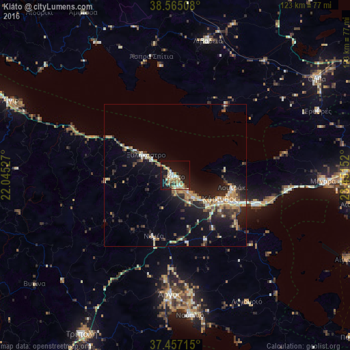
Analysis of Kiáto night lights 2016
Square area 10x10 km:
 2.44%
2.44%90-99
6.33%80-89
5.52%70-79
5.36%60-69
8.28%50-59
2.6%40-49
1.3%30-39
3.41%20-29
7.63%10-19
37.01%0-9
20.13%Square area 50x50 km:
0.53%90-99
1.72%80-89
1.42%70-79
1.62%60-69
1.66%50-59
0.76%40-49
1.18%30-39
2.5%20-29
3.09%10-19
8.56%0-9
76.97%Clear (daylight) street map image can be seen on geolist.org.
Map coordinates:
38° 33' 54.3" North, 22° 2' 43" East
38° 0' 47.6" North, 22° 44' 54.2" East
37° 27' 25.7" North, 23° 27' 5.5" East
Some cities around Kiáto sort by population:
• Kórinthos
19.6 km =12.2 mi,  114°
114°
• Mégara
52.2 km =32.4 mi,  92°
92°
• Árgos
42.3 km =26.3 mi,  181°
181°
• Livadeiá
48.3 km =30 mi,  13°
13°
• Náfplio
49.7 km =30.9 mi,  174°
174°
• Loutráki
20.5 km =12.7 mi,  100°
100°
• Orchomenós
57 km =35.4 mi,  20°
20°
• Xylókastro
12.5 km =7.8 mi,  305°
305°
259830 (p: 9,812)
Sources (retrieved 2019-11-25):
» Earth at Night: Flat Maps 2012, 2016