Náfplio night lights from space
Night Light of Náfplio (Peloponnese) from space (Greece) Src. Average luminocity for 10x10km area is 39.7305% and for 50x50km: 7.2224%.
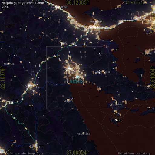
Analysis of Náfplio night lights 2016
Square area 10x10 km:
 3.08%
3.08%90-99
7.14%80-89
6.17%70-79
5.68%60-69
7.95%50-59
3.08%40-49
5.84%30-39
11.36%20-29
11.36%10-19
26.62%0-9
11.69%Square area 50x50 km:
0.21%90-99
0.93%80-89
1.18%70-79
0.99%60-69
1.21%50-59
0.56%40-49
1.48%30-39
2.06%20-29
2.33%10-19
4.32%0-9
84.73%Clear (daylight) street map image can be seen on geolist.org.
Map coordinates:
38° 7' 25.9" North, 22° 6' 13.6" East
37° 34' 7.1" North, 22° 48' 24.9" East
37° 0' 33.3" North, 23° 30' 36.1" East
Some cities around Náfplio sort by population:
• Kórinthos
43.2 km =26.8 mi,  17°
17°
• Trípoli
38.3 km =23.8 mi,  260°
260°
• Árgos
9.7 km =6 mi,  317°
317°
• Loutráki
48 km =29.8 mi, 18°
• Kiáto
49.7 km =30.9 mi,  354°
354°
• Aegina
58.1 km =36.1 mi,  70°
70°
• Xylókastro
58.7 km =36.5 mi,  344°
344°
• Megalópoli
61.5 km =38.2 mi,  252°
252°
256637 (p: 14,582)
Sources (retrieved 2019-11-25):
» Earth at Night: Flat Maps 2012, 2016