Chalástra night lights from space
Night Light of Chalástra (Central Macedonia) from space (Greece) Src. Average luminocity for 10x10km area is 19.6623% and for 50x50km: 21.0153%.
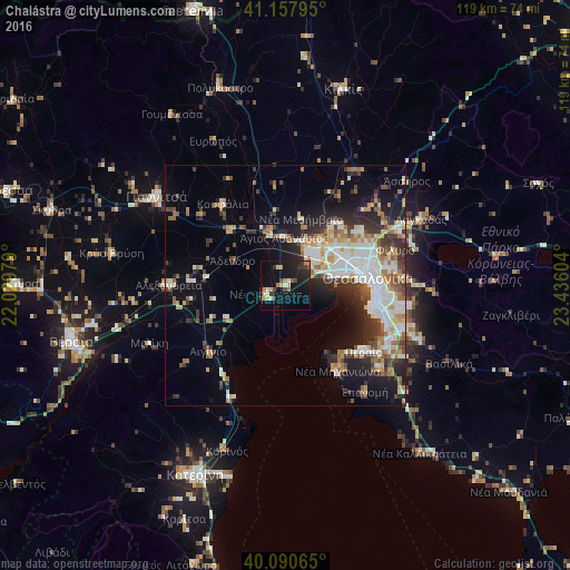
Analysis of Chalástra night lights 2016
Square area 10x10 km:
 0%
0%90-99
2.92%80-89
2.92%70-79
4.38%60-69
1.14%50-59
1.62%40-49
2.44%30-39
4.06%20-29
5.03%10-19
23.7%0-9
51.79%Square area 50x50 km:
3.97%90-99
4.27%80-89
2.13%70-79
2.54%60-69
2.9%50-59
2.05%40-49
2.39%30-39
3.46%20-29
4.94%10-19
8.91%0-9
62.43%Clear (daylight) street map image can be seen on geolist.org.
Map coordinates:
41° 9' 28.6" North, 22° 1' 47.2" East
40° 37' 35.1" North, 22° 43' 58.5" East
40° 5' 26.3" North, 23° 26' 9.7" East
Some cities around Chalástra sort by population:
• Thessaloníki
16.8 km =10.4 mi,  83°
83°
• Kalamariá
19 km =11.8 mi,  104°
104°
• Sykiés
18.6 km =11.6 mi, 82°
• Políchni
18.8 km =11.7 mi, 76°
• Neapoli
17.9 km =11.1 mi, 80°
• Meneméni
14.3 km =8.9 mi, 75°
• Diavatá
12.5 km =7.8 mi,  57°
57°
• Síndos
7.8 km =4.8 mi,  51°
51°
734622 (p: 7,360)
Sources (retrieved 2019-11-25):
» Earth at Night: Flat Maps 2012, 2016