Meneméni night lights from space
Night Light of Meneméni (Central Macedonia) from space (Greece) Src. Average luminocity for 10x10km area is 82.9464% and for 50x50km: 21.2775%.
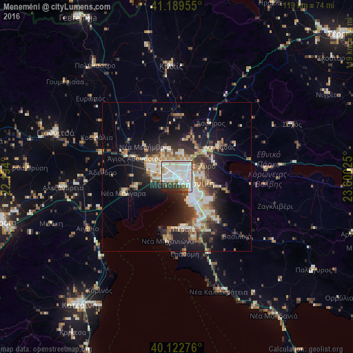
Analysis of Meneméni night lights 2016
Square area 10x10 km:
 41.88%
90-99
27.27%80-89
3.9%70-79
2.27%60-69
2.92%50-59
2.76%40-49
3.9%30-39
6.98%20-29
6.82%10-19
1.3%0-9
0%Square area 50x50 km:
4%90-99
4.46%80-89
2.04%70-79
2.33%60-69
2.83%50-59
2.17%40-49
2.45%30-39
3.76%20-29
6.1%10-19
10.6%0-9
59.27%Clear (daylight) street map image can be seen on geolist.org.
Map coordinates:
41° 11' 22.4" North, 22° 11' 38.4" East
40° 39' 29.8" North, 22° 53' 49.6" East
40° 7' 21.9" North, 23° 36' 0.9" East
Some cities around Meneméni sort by population:
• Thessaloníki
3.3 km =2.1 mi,  119°
119°
• Sykiés
4.6 km =2.9 mi,  102°
102°
• Políchni
4.5 km =2.8 mi,  77°
77°
• Neapoli
3.8 km =2.4 mi, 98°
• Oraiókastro
8.2 km =5.1 mi,  11°
11°
• Diavatá
4.6 km =2.9 mi,  314°
314°
• Síndos
7.8 km =4.8 mi,  279°
279°
• Ágios Pávlos
5.7 km =3.5 mi,  110°
110°
735215 (p: 15,706)
Sources (retrieved 2019-11-25):
» Earth at Night: Flat Maps 2012, 2016