Aegina night lights from space
Night Light of Aegina (Attica) from space (Greece) Src. Average luminocity for 10x10km area is 9.6463% and for 50x50km: 6.4454%.
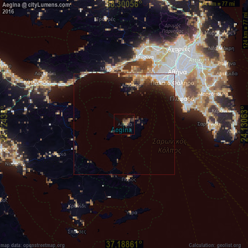
Analysis of Aegina night lights 2016
Square area 10x10 km:
 0%
0%90-99
0%80-89
0%70-79
1.7%60-69
3.74%50-59
1.7%40-49
1.7%30-39
4.25%20-29
3.91%10-19
1.19%0-9
81.8%Square area 50x50 km:
1.19%90-99
1%80-89
0.41%70-79
0.56%60-69
1.13%50-59
0.77%40-49
0.91%30-39
1.39%20-29
2.15%10-19
3.4%0-9
87.09%Clear (daylight) street map image can be seen on geolist.org.
Map coordinates:
38° 18' 2" North, 22° 43' 27.8" East
37° 44' 48" North, 23° 25' 39" East
37° 11' 19" North, 24° 7' 50.3" East
Some cities around Aegina sort by population:
• Piraeus
29 km =18 mi,  41°
41°
• Níkaia
31.3 km =19.4 mi, 38°
• Keratsíni
29.3 km =18.2 mi, 35°
• Pérama
27.7 km =17.2 mi,  27°
27°
• Salamína
24.9 km =15.5 mi,  14°
14°
• Mégara
28.6 km =17.8 mi,  344°
344°
• Drapetsóna
28.4 km =17.6 mi, 37°
• Néa Péramos
28.9 km =18 mi,  359°
359°
265502 (p: 6,867)
Sources (retrieved 2019-11-25):
» Earth at Night: Flat Maps 2012, 2016