Gali night lights from space
Night Light of Gali (Abkhazia) from space (Georgia) Src. Average luminocity for 10x10km area is 12.2955% and for 50x50km: 2.9529%.
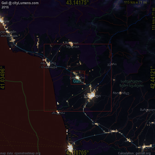
Analysis of Gali night lights 2016
Square area 10x10 km:
 0.15%
0.15%90-99
1.67%80-89
0.61%70-79
1.67%60-69
2.12%50-59
1.82%40-49
3.03%30-39
4.55%20-29
2.88%10-19
2.88%0-9
78.64%Square area 50x50 km:
0.21%90-99
0.39%80-89
0.29%70-79
0.34%60-69
0.52%50-59
0.32%40-49
0.51%30-39
0.55%20-29
0.63%10-19
2.09%0-9
94.17%Clear (daylight) street map image can be seen on geolist.org.
Map coordinates:
43° 8' 30.3" North, 41° 2' 5.9" East
42° 37' 35.6" North, 41° 44' 17.1" East
42° 6' 25.4" North, 42° 26' 28.4" East
Some cities around Gali sort by population:
• Zugdidi
17 km =10.6 mi,  140°
140°
• P’ot’i
54.1 km =33.6 mi,  185°
185°
• Senak’i
47.9 km =29.8 mi,  145°
145°
• Tqvarch'eli
24.2 km =15 mi,  348°
348°
• Och’amch’ire
24 km =14.9 mi,  293°
293°
• Tsalenjikha
27.1 km =16.8 mi,  95°
95°
• Mart’vili
57.6 km =35.8 mi,  114°
114°
• Khobi
37 km =23 mi,  159°
159°
614613 (p: 11,861)
Sources (retrieved 2019-11-25):
» Earth at Night: Flat Maps 2012, 2016