Watton night lights from space
Night Light of Watton (England) from space (United Kingdom) Src. Average luminocity for 10x10km area is 0.4233% and for 50x50km: 6.9327%.
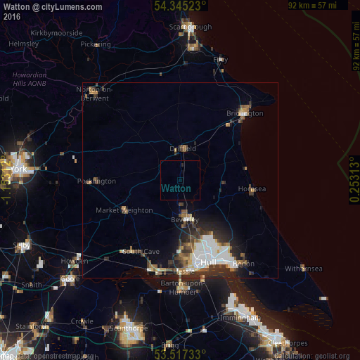
Analysis of Watton night lights 2016
Square area 10x10 km:
 0%
0%90-99
0%80-89
0%70-79
0%60-69
0%50-59
0%40-49
0%30-39
0%20-29
0.53%10-19
0.13%0-9
99.34%Square area 50x50 km:
1.34%90-99
1.45%80-89
0.5%70-79
0.5%60-69
0.75%50-59
0.98%40-49
1.02%30-39
1.38%20-29
2.22%10-19
3.1%0-9
86.77%Clear (daylight) street map image can be seen on geolist.org.
Map coordinates:
54° 20' 42.8" North, 1° 9' 11.2" West
53° 55' 60" North, 0° 27' 0" West
53° 31' 2.4" North, 0° 15' 11.3" East
Some cities around Watton sort by population:
• Kingston upon Hull
22.3 km =13.9 mi,  160°
160°
• Bridlington
23.7 km =14.7 mi,  45°
45°
• Beverley
9.9 km =6.2 mi,  169°
169°
• Driffield
8.1 km =5 mi,  2°
2°
• Hornsea
18.6 km =11.6 mi,  97°
97°
• Pocklington
21.7 km =13.5 mi,  270°
270°
• North Ferriby
23.9 km =14.9 mi,  188°
188°
• Market Weighton
16.1 km =10 mi,  241°
241°
2634661 (p: 7,601)
Sources (retrieved 2019-11-25):
» Earth at Night: Flat Maps 2012, 2016