Troon night lights from space
Night Light of Troon (Scotland) from space (United Kingdom) Src. Average luminocity for 10x10km area is 20.0526% and for 50x50km: 6.4125%.
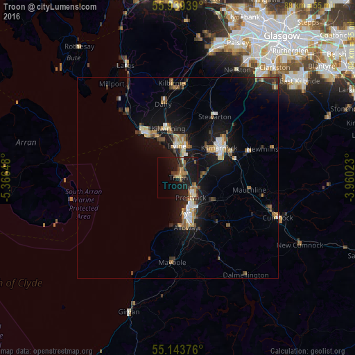
Analysis of Troon night lights 2016
Square area 10x10 km:
 0.5%
0.5%90-99
1.75%80-89
0.75%70-79
3.51%60-69
4.76%50-59
4.26%40-49
2.01%30-39
4.39%20-29
4.01%10-19
32.71%0-9
41.35%Square area 50x50 km:
0.64%90-99
0.87%80-89
0.56%70-79
0.84%60-69
0.82%50-59
1.03%40-49
0.75%30-39
0.84%20-29
1.33%10-19
7.36%0-9
84.96%Clear (daylight) street map image can be seen on geolist.org.
Map coordinates:
55° 56' 21.8" North, 5° 21' 59.3" West
55° 32' 36.9" North, 4° 39' 48.1" West
55° 8' 37.5" North, 3° 57' 36.8" West
Some cities around Troon sort by population:
• Ayr
9.2 km =5.7 mi,  168°
168°
• Kilmarnock
13 km =8.1 mi,  54°
54°
• Irvine
8.4 km =5.2 mi,  3°
3°
• Kilwinning
12.5 km =7.8 mi,  347°
347°
• Prestwick
7.3 km =4.5 mi,  156°
156°
• Saltcoats
12.9 km =8 mi,  323°
323°
• Ardrossan
14.9 km =9.3 mi, 322°
• Stevenston
12.1 km =7.5 mi,  332°
332°
2635442 (p: 14,680)
Sources (retrieved 2019-11-25):
» Earth at Night: Flat Maps 2012, 2016