Stonehaven night lights from space
Night Light of Stonehaven (Scotland) from space (United Kingdom) Src. Average luminocity for 10x10km area is 3.6909% and for 50x50km: 4.6776%.
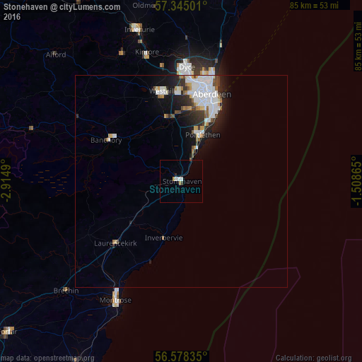
Analysis of Stonehaven night lights 2016
Square area 10x10 km:
 0.34%
0.34%90-99
1.48%80-89
0%70-79
0.45%60-69
0.45%50-59
0.23%40-49
0%30-39
0.45%20-29
0.45%10-19
0%0-9
96.14%Square area 50x50 km:
1.4%90-99
1.12%80-89
0.22%70-79
0.34%60-69
0.38%50-59
0.34%40-49
0.41%30-39
0.58%20-29
1.17%10-19
2.48%0-9
91.56%Clear (daylight) street map image can be seen on geolist.org.
Map coordinates:
57° 20' 42" North, 2° 54' 53.6" West
56° 57' 49.1" North, 2° 12' 42.4" West
56° 34' 42.1" North, 1° 30' 31.1" West
Some cities around Stonehaven sort by population:
• Aberdeen
21.2 km =13.2 mi,  18°
18°
• Inverurie
37 km =23 mi,  344°
344°
• Montrose
31.5 km =19.6 mi,  209°
209°
• Westhill
21.4 km =13.3 mi,  348°
348°
• Portlethen
12.7 km =7.9 mi, 22°
• Banchory
19.4 km =12.1 mi,  300°
300°
• Cove
17 km =10.6 mi,  27°
27°
• Dyce
26.9 km =16.7 mi,  4°
4°
2636814 (p: 11,370)
Sources (retrieved 2019-11-25):
» Earth at Night: Flat Maps 2012, 2016