Largs night lights from space
Night Light of Largs (Scotland) from space (United Kingdom) Src. Average luminocity for 10x10km area is 4.0227% and for 50x50km: 8.0938%.
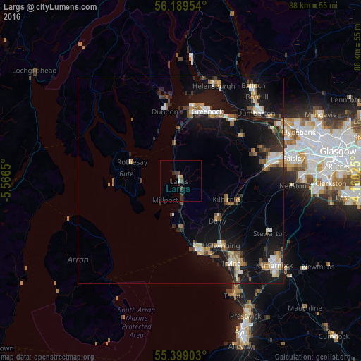
Analysis of Largs night lights 2016
Square area 10x10 km:
 0.36%
0.36%90-99
0.6%80-89
0%70-79
0.48%60-69
0%50-59
0.96%40-49
0.48%30-39
2.87%20-29
1.44%10-19
0%0-9
92.82%Square area 50x50 km:
1.02%90-99
1.15%80-89
0.73%70-79
0.88%60-69
1.01%50-59
1.1%40-49
0.95%30-39
1.19%20-29
1.81%10-19
9%0-9
81.16%Clear (daylight) street map image can be seen on geolist.org.
Map coordinates:
56° 11' 22.3" North, 5° 33' 59.4" West
55° 47' 46.6" North, 4° 51' 48.1" West
55° 23' 56.5" North, 4° 9' 36.9" West
Some cities around Largs sort by population:
• Greenock
18.1 km =11.2 mi,  20°
20°
• Saltcoats
18.5 km =11.5 mi,  164°
164°
• Ardrossan
16.6 km =10.3 mi,  167°
167°
• Dunoon
17.6 km =10.9 mi,  346°
346°
• Kilbirnie
12.1 km =7.5 mi,  114°
114°
• Isle of Bute
12.8 km =8 mi,  290°
290°
• Beith
15.1 km =9.4 mi, 110°
• Dalry
13.1 km =8.1 mi,  137°
137°
2644860 (p: 11,340)
Sources (retrieved 2019-11-25):
» Earth at Night: Flat Maps 2012, 2016