Kirkby night lights from space
Night Light of Kirkby (England) from space (United Kingdom) Src. Average luminocity for 10x10km area is 71.6799% and for 50x50km: 37.9367%.

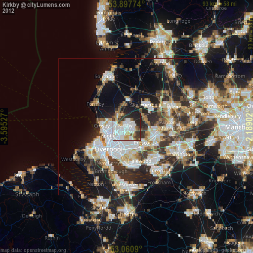
Analysis of Kirkby night lights 2016
Square area 10x10 km:
100  29.23%
90-99 18.25%
80-89 4.23%
70-79 5.42%
60-69 7.01%
50-59 4.23%
40-49 7.41%
30-39 9.39%
20-29 14.29%
10-19 0.53%
0-9 0%
29.23%90-99
18.25%80-89
4.23%70-79
5.42%60-69
7.01%50-59
4.23%40-49
7.41%30-39
9.39%20-29
14.29%10-19
0.53%0-9
0%Square area 50x50 km:
100 9.45%
90-99 8.69%
80-89 3.38%
70-79 3.31%
60-69 3.97%
50-59 4%
40-49 5.87%
30-39 6.9%
20-29 9.49%
10-19 13.98%
0-9 30.95%
9.45%90-99
8.69%80-89
3.38%70-79
3.31%60-69
3.97%50-59
4%40-49
5.87%30-39
6.9%20-29
9.49%10-19
13.98%0-9
30.95%Clear (daylight) street map image can be seen on geolist.org.
Map coordinates:
53° 53' 51.9" North, 3° 35' 43" West
53° 28' 53" North, 2° 53' 31.7" West
53° 3' 39.2" North, 2° 11' 20.5" West
Some cities around Kirkby sort by population:
• Bootle
8.4 km =5.2 mi,  258°
258°
• Huyton
8.5 km =5.3 mi,  155°
155°
• Crosby
9.4 km =5.8 mi,  267°
267°
• Prescot
8.4 km =5.2 mi,  133°
133°
• Maghull
5 km =3.1 mi,  320°
320°
• Ormskirk
9.5 km =5.9 mi,  4°
4°
• Litherland
7.1 km =4.4 mi, 259°
• Rainford
7.2 km =4.5 mi,  71°
71°
2645313 (p: 42,744)
Sources (retrieved 2019-11-25):
» Earth at Night: Flat Maps 2012, 2016