East Tilbury night lights from space
Night Light of East Tilbury (England) from space (United Kingdom) Src. Average luminocity for 10x10km area is 47.266% and for 50x50km: 37.9009%.
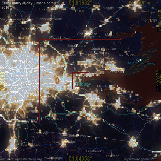
Analysis of East Tilbury night lights 2016
Square area 10x10 km:
 7.09%
7.09%90-99
9.89%80-89
6.28%70-79
5.88%60-69
5.21%50-59
4.55%40-49
8.69%30-39
6.68%20-29
21.79%10-19
23.93%0-9
0%Square area 50x50 km:
7.55%90-99
8.13%80-89
4.26%70-79
4.56%60-69
4.42%50-59
4.33%40-49
4.72%30-39
5.84%20-29
10.61%10-19
18.33%0-9
27.25%Clear (daylight) street map image can be seen on geolist.org.
Map coordinates:
51° 54' 58.8" North, 0° 17' 9.5" West
51° 28' 49.9" North, 0° 25' 1.7" East
51° 2' 25.9" North, 1° 7' 13" East
Some cities around East Tilbury sort by population:
• Grays
6.4 km =4 mi,  265°
265°
• Gravesend
5.3 km =3.3 mi,  216°
216°
• Stanford-le-Hope
4.8 km =3 mi,  14°
14°
• Swanscombe
8.3 km =5.2 mi,  243°
243°
• Chafford Hundred
8.6 km =5.3 mi,  276°
276°
• Tilbury
4.5 km =2.8 mi, 243°
• Chadwell St Mary
3.7 km =2.3 mi, 271°
• West Thurrock
9.7 km =6 mi, 268°
2650325 (p: 5,471)
Sources (retrieved 2019-11-25):
» Earth at Night: Flat Maps 2012, 2016