Chadwell St Mary night lights from space
Night Light of Chadwell St Mary (England) from space (United Kingdom) Src. Average luminocity for 10x10km area is 65.3316% and for 50x50km: 41.4033%.
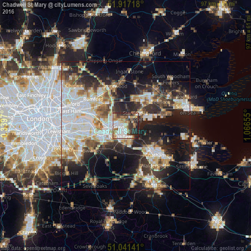
Analysis of Chadwell St Mary night lights 2016
Square area 10x10 km:
 15.64%
90-99
16.71%80-89
8.69%70-79
7.35%60-69
10.29%50-59
5.61%40-49
7.75%30-39
9.09%20-29
15.51%10-19
3.34%0-9
0%Square area 50x50 km:
9.54%90-99
9.08%80-89
4.75%70-79
4.53%60-69
4.7%50-59
4.54%40-49
5%30-39
6.11%20-29
10.38%10-19
16.52%0-9
24.82%Clear (daylight) street map image can be seen on geolist.org.
Map coordinates:
51° 55' 1.8" North, 0° 20' 22.9" West
51° 28' 53" North, 0° 21' 48.3" East
51° 2' 29.1" North, 1° 3' 59.6" East
Some cities around Chadwell St Mary sort by population:
• Grays
2.7 km =1.7 mi,  256°
256°
• Gravesend
4.4 km =2.7 mi,  173°
173°
• South Ockendon
6.3 km =3.9 mi,  298°
298°
• Swanscombe
5.3 km =3.3 mi,  224°
224°
• Chafford Hundred
4.9 km =3 mi,  280°
280°
• Tilbury
2.1 km =1.3 mi,  189°
189°
• West Thurrock
6 km =3.7 mi,  266°
266°
• East Tilbury
3.7 km =2.3 mi,  91°
91°
6690812 (p: 9,631)
Sources (retrieved 2019-11-25):
» Earth at Night: Flat Maps 2012, 2016