Broadstone night lights from space
Night Light of Broadstone (England) from space (United Kingdom) Src. Average luminocity for 10x10km area is 44.4051% and for 50x50km: 6.4063%.
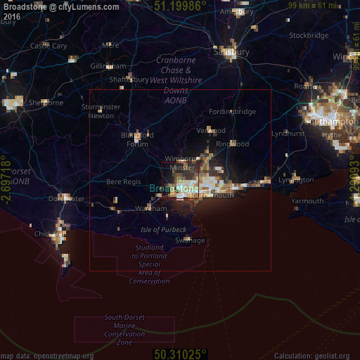
Analysis of Broadstone night lights 2016
Square area 10x10 km:
 6.42%
6.42%90-99
8.82%80-89
6.55%70-79
6.82%60-69
3.88%50-59
6.55%40-49
7.35%30-39
9.63%20-29
13.24%10-19
15.51%0-9
15.24%Square area 50x50 km:
0.56%90-99
1.19%80-89
0.66%70-79
0.85%60-69
0.96%50-59
0.94%40-49
0.95%30-39
0.97%20-29
2.2%10-19
3.87%0-9
86.84%Clear (daylight) street map image can be seen on geolist.org.
Map coordinates:
51° 11' 59.5" North, 2° 41' 49.8" West
50° 45' 25.8" North, 1° 59' 38.6" West
50° 18' 36.9" North, 1° 17' 27.3" West
Some cities around Broadstone sort by population:
• Bournemouth
9 km =5.6 mi,  116°
116°
• Poole
4.8 km =3 mi,  172°
172°
• Ferndown
8.7 km =5.4 mi,  49°
49°
• Wimborne Minster
3 km =1.9 mi,  14°
14°
• Canford Heath
1.9 km =1.2 mi,  110°
110°
• Parkstone
4.6 km =2.9 mi,  131°
131°
• Wareham
11.2 km =7 mi,  226°
226°
• St Leonards
13.4 km =8.3 mi, 52°
2654634 (p: 10,256)
Sources (retrieved 2019-11-25):
» Earth at Night: Flat Maps 2012, 2016