Airdrie night lights from space
Night Light of Airdrie (Scotland) from space (United Kingdom) Src. Average luminocity for 10x10km area is 60.8045% and for 50x50km: 29.5672%.

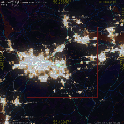
Analysis of Airdrie night lights 2016
Square area 10x10 km:
 20.05%
90-99
16.29%80-89
2.38%70-79
6.27%60-69
4.76%50-59
6.39%40-49
3.88%30-39
15.79%20-29
12.03%10-19
9.52%0-9
2.63%Square area 50x50 km:
8.15%90-99
7.39%80-89
1.97%70-79
2.67%60-69
2.8%50-59
2.5%40-49
2.98%30-39
3.81%20-29
7.63%10-19
14.47%0-9
45.63%Clear (daylight) street map image can be seen on geolist.org.
Map coordinates:
56° 15' 30.8" North, 4° 41' 0.2" West
55° 51' 57.7" North, 3° 58' 48.9" West
55° 28' 10.1" North, 3° 16' 37.7" West
Some cities around Airdrie sort by population:
• Coatbridge
2.8 km =1.7 mi,  261°
261°
• Bellshill
5.9 km =3.7 mi,  202°
202°
• Viewpark
6.4 km =4 mi,  228°
228°
• Chapelhall
3.2 km =2 mi,  141°
141°
• Newarthill
6.3 km =3.9 mi,  154°
154°
• Uddingston
8.3 km =5.2 mi, 231°
• New Stevenston
5.5 km =3.4 mi,  175°
175°
• Holytown
5.1 km =3.2 mi,  174°
174°
2657613 (p: 37,130)
Sources (retrieved 2019-11-25):
» Earth at Night: Flat Maps 2012, 2016