Lutterbach night lights from space
Night Light of Lutterbach (Grand Est) from space (France) Src. Average luminocity for 10x10km area is 64.2545% and for 50x50km: 19.0353%.
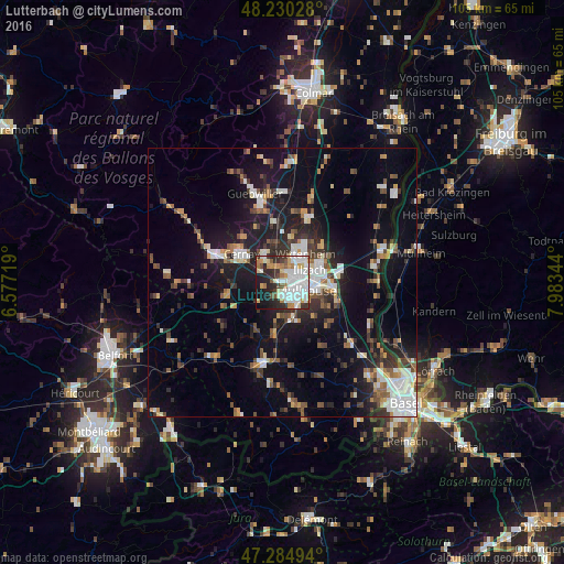
Analysis of Lutterbach night lights 2016
Square area 10x10 km:
 26.49%
90-99
12.95%80-89
5.36%70-79
7.29%60-69
6.55%50-59
3.13%40-49
3.27%30-39
6.85%20-29
14.43%10-19
12.2%0-9
1.49%Square area 50x50 km:
3.46%90-99
3.28%80-89
1.27%70-79
1.96%60-69
1.68%50-59
2.49%40-49
2.65%30-39
2.9%20-29
4.91%10-19
14.79%0-9
60.61%Clear (daylight) street map image can be seen on geolist.org.
Map coordinates:
48° 13' 49" North, 6° 34' 37.9" East
47° 45' 35.1" North, 7° 16' 49.2" East
47° 17' 5.8" North, 7° 59' 0.4" East
Some cities around Lutterbach sort by population:
• Mulhouse
3.7 km =2.3 mi,  103°
103°
• Wittenheim
6.7 km =4.2 mi,  31°
31°
• Illzach
5.6 km =3.5 mi,  73°
73°
• Riedisheim
6.6 km =4.1 mi, 100°
• Kingersheim
4.9 km =3 mi,  44°
44°
• Wittelsheim
6.2 km =3.9 mi,  332°
332°
• Pfastatt
2 km =1.2 mi,  58°
58°
• Brunstatt
5.2 km =3.2 mi,  145°
145°
2997010 (p: 6,180)
Sources (retrieved 2019-11-25):
» Earth at Night: Flat Maps 2012, 2016