Saint-Jean-Bonnefonds night lights from space
Night Light of Saint-Jean-Bonnefonds (Auvergne-Rhône-Alpes) from space (France) Src. Average luminocity for 10x10km area is 61.1667% and for 50x50km: 15.179%.
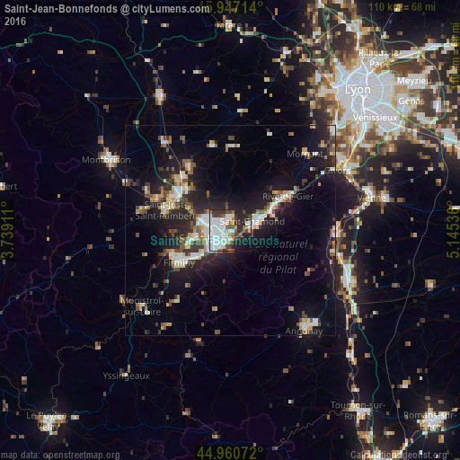
Analysis of Saint-Jean-Bonnefonds night lights 2016
Square area 10x10 km:
 20.48%
90-99
19.37%80-89
3.17%70-79
2.54%60-69
4.92%50-59
3.65%40-49
7.46%30-39
8.1%20-29
16.98%10-19
12.06%0-9
1.27%Square area 50x50 km:
2.25%90-99
2.8%80-89
1.26%70-79
1.45%60-69
1.57%50-59
1.73%40-49
2.21%30-39
2.09%20-29
5.4%10-19
11.88%0-9
67.35%Clear (daylight) street map image can be seen on geolist.org.
Map coordinates:
45° 56' 49.7" North, 3° 44' 20.8" East
45° 27' 21.9" North, 4° 26' 32" East
44° 57' 38.6" North, 5° 8' 43.3" East
Some cities around Saint-Jean-Bonnefonds sort by population:
• Firminy
14.1 km =8.8 mi,  238°
238°
• Le Chambon-Feugerolles
11.9 km =7.4 mi,  232°
232°
• Roche-la-Molière
9.3 km =5.8 mi,  252°
252°
• Villars
6.9 km =4.3 mi,  280°
280°
• La Ricamarie
8 km =5 mi, 225°
• Sorbiers
3.9 km =2.4 mi,  359°
359°
• La Talaudière
2.6 km =1.6 mi,  330°
330°
• La Grand-Croix
10.5 km =6.5 mi,  59°
59°
2979371 (p: 6,076)
Sources (retrieved 2019-11-25):
» Earth at Night: Flat Maps 2012, 2016