Vauvert night lights from space
Night Light of Vauvert (Occitanie) from space (France) Src. Average luminocity for 10x10km area is 22.5439% and for 50x50km: 17.8643%.
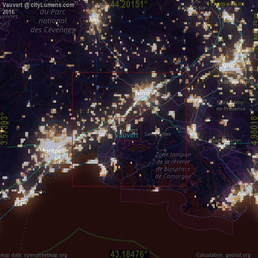
Analysis of Vauvert night lights 2016
Square area 10x10 km:
 1.36%
1.36%90-99
2.88%80-89
3.79%70-79
4.24%60-69
1.97%50-59
2.42%40-49
2.12%30-39
0.61%20-29
7.58%10-19
33.03%0-9
40%Square area 50x50 km:
2.12%90-99
3.48%80-89
2.37%70-79
1.49%60-69
2.04%50-59
1.58%40-49
1.96%30-39
1.78%20-29
7.91%10-19
16.84%0-9
58.44%Clear (daylight) street map image can be seen on geolist.org.
Map coordinates:
44° 12' 5.4" North, 3° 34' 26.1" East
43° 41' 43" North, 4° 16' 37.4" East
43° 11' 5.1" North, 4° 58' 48.6" East
Some cities around Vauvert sort by population:
• Nîmes
16.8 km =10.4 mi,  23°
23°
• Lunel
11.5 km =7.1 mi,  260°
260°
• Saint-Gilles
12.5 km =7.8 mi,  99°
99°
• Aigues-Mortes
15.9 km =9.9 mi,  205°
205°
• Marsillargues
8.9 km =5.5 mi,  247°
247°
• Bouillargues
16.6 km =10.3 mi,  47°
47°
• Bellegarde
20.3 km =12.6 mi,  71°
71°
• Milhaud
10.8 km =6.7 mi,  14°
14°
2970407 (p: 10,798)
Sources (retrieved 2019-11-25):
» Earth at Night: Flat Maps 2012, 2016