Saint-Gilles night lights from space
Night Light of Saint-Gilles (Occitanie) from space (France) Src. Average luminocity for 10x10km area is 9.2879% and for 50x50km: 16.0546%.
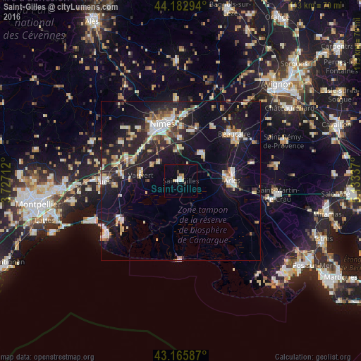
Analysis of Saint-Gilles night lights 2016
Square area 10x10 km:
 1.36%
1.36%90-99
1.67%80-89
1.67%70-79
0.76%60-69
0.61%50-59
0%40-49
1.21%30-39
0.61%20-29
0.61%10-19
0.15%0-9
91.36%Square area 50x50 km:
2.07%90-99
3.07%80-89
2.08%70-79
1.46%60-69
1.67%50-59
1.6%40-49
1.8%30-39
1.3%20-29
5.86%10-19
15.4%0-9
63.7%Clear (daylight) street map image can be seen on geolist.org.
Map coordinates:
44° 10' 58.6" North, 3° 43' 37.6" East
43° 40' 35.6" North, 4° 25' 48.9" East
43° 9' 57.1" North, 5° 8' 0.1" East
Some cities around Saint-Gilles sort by population:
• Nîmes
18.4 km =11.4 mi,  342°
342°
• Arles
16.1 km =10 mi,  89°
89°
• Vauvert
12.5 km =7.8 mi,  279°
279°
• Marguerittes
20.4 km =12.7 mi,  3°
3°
• Manduel
16.1 km =10 mi,  12°
12°
• Bouillargues
13.4 km =8.3 mi,  359°
359°
• Bellegarde
11 km =6.8 mi,  39°
39°
• Milhaud
15.9 km =9.9 mi,  322°
322°
2979679 (p: 13,231)
Sources (retrieved 2019-11-25):
» Earth at Night: Flat Maps 2012, 2016