Lunel night lights from space
Night Light of Lunel (Occitanie) from space (France) Src. Average luminocity for 10x10km area is 42.0561% and for 50x50km: 23.261%.

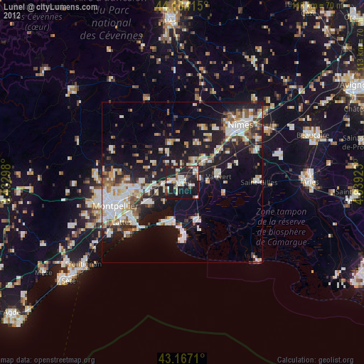
Analysis of Lunel night lights 2016
Square area 10x10 km:
 5.61%
5.61%90-99
10%80-89
5.45%70-79
3.94%60-69
6.97%50-59
2.88%40-49
1.21%30-39
3.18%20-29
33.03%10-19
25.61%0-9
2.12%Square area 50x50 km:
4.27%90-99
4.86%80-89
2.75%70-79
2.19%60-69
2.56%50-59
2.1%40-49
2.41%30-39
2.64%20-29
9.01%10-19
16.52%0-9
50.69%Clear (daylight) street map image can be seen on geolist.org.
Map coordinates:
44° 11' 2.9" North, 3° 25' 58.7" East
43° 40' 40" North, 4° 8' 10" East
43° 10' 1.6" North, 4° 50' 21.2" East
Some cities around Lunel sort by population:
• Mauguio
12.3 km =7.6 mi,  237°
237°
• Vauvert
11.5 km =7.1 mi,  80°
80°
• La Grande-Motte
13.1 km =8.1 mi,  198°
198°
• Baillargues
9.7 km =6 mi,  260°
260°
• Aigues-Mortes
13.1 km =8.1 mi,  160°
160°
• Marsillargues
3.4 km =2.1 mi,  116°
116°
• Vendargues
13.5 km =8.4 mi, 260°
• Castries
12.4 km =7.7 mi,  270°
270°
2997116 (p: 26,588)
Sources (retrieved 2019-11-25):
» Earth at Night: Flat Maps 2012, 2016