Templeuve-en-Pévèle night lights from space
Night Light of Templeuve-en-Pévèle (Hauts-de-France) from space (France) Src. Average luminocity for 10x10km area is 30.9048% and for 50x50km: 49.9734%.
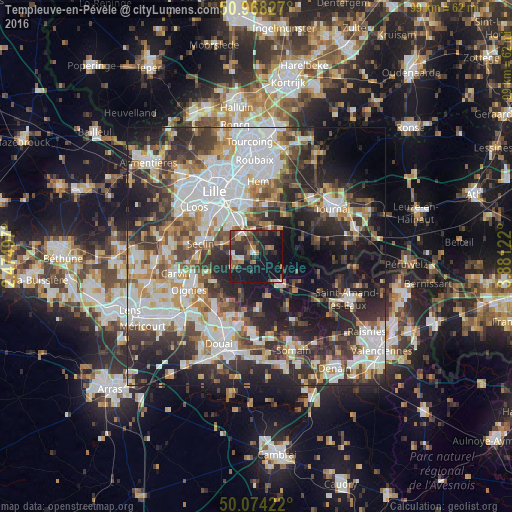
Analysis of Templeuve-en-Pévèle night lights 2016
Square area 10x10 km:
 2.66%
2.66%90-99
2.24%80-89
2.1%70-79
3.92%60-69
5.18%50-59
4.34%40-49
7.98%30-39
7.7%20-29
12.89%10-19
44.4%0-9
6.58%Square area 50x50 km:
13.21%90-99
10.67%80-89
4.14%70-79
5.03%60-69
5.91%50-59
5.77%40-49
6.78%30-39
8.63%20-29
14.68%10-19
15.93%0-9
9.25%Clear (daylight) street map image can be seen on geolist.org.
Map coordinates:
50° 58' 5.8" North, 2° 28' 29.9" East
50° 31' 24.1" North, 3° 10' 41.1" East
50° 4' 27.2" North, 3° 52' 52.4" East
Some cities around Templeuve-en-Pévèle sort by population:
• Villeneuve-d'Ascq
10.4 km =6.5 mi,  355°
355°
• Ronchin
10.4 km =6.5 mi,  323°
323°
• Faches-Thumesnil
10.3 km =6.4 mi,  310°
310°
• Wattignies
11.8 km =7.3 mi, 306°
• Seclin
11 km =6.8 mi,  284°
284°
• Orchies
7.4 km =4.6 mi,  148°
148°
• Lesquin
7.8 km =4.8 mi,  327°
327°
• Flines-lez-Raches
11.9 km =7.4 mi,  178°
178°
2973187 (p: 5,901)
Sources (retrieved 2019-11-25):
» Earth at Night: Flat Maps 2012, 2016