Sully-sur-Loire night lights from space
Night Light of Sully-sur-Loire (Centre) from space (France) Src. Average luminocity for 10x10km area is 9.8839% and for 50x50km: 2.254%.
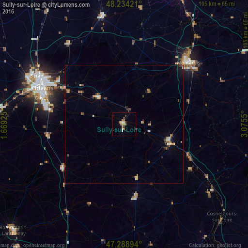
Analysis of Sully-sur-Loire night lights 2016
Square area 10x10 km:
 0.89%
0.89%90-99
1.19%80-89
0.89%70-79
1.79%60-69
2.38%50-59
1.34%40-49
1.64%30-39
0.89%20-29
0%10-19
0.74%0-9
88.24%Square area 50x50 km:
0.11%90-99
0.27%80-89
0.25%70-79
0.33%60-69
0.31%50-59
0.38%40-49
0.53%30-39
0.41%20-29
0.25%10-19
0.4%0-9
96.78%Clear (daylight) street map image can be seen on geolist.org.
Map coordinates:
48° 14' 3.2" North, 1° 40' 9.3" East
47° 45' 49.4" North, 2° 22' 20.6" East
47° 17' 20.2" North, 3° 4' 31.8" East
Some cities around Sully-sur-Loire sort by population:
• Saint-Jean-de-Braye
33.9 km =21.1 mi,  299°
299°
• Gien
20.9 km =13 mi,  112°
112°
• Chécy
29.8 km =18.5 mi, 299°
• Saint-Denis-en-Val
32.7 km =20.3 mi,  291°
291°
• Châteauneuf-sur-Loire
16.1 km =10 mi,  314°
314°
• La Ferté-Saint-Aubin
32.8 km =20.4 mi,  260°
260°
• Briare
31.3 km =19.4 mi,  117°
117°
• Aubigny-sur-Nère
31 km =19.3 mi,  170°
170°
2973703 (p: 6,285)
Sources (retrieved 2019-11-25):
» Earth at Night: Flat Maps 2012, 2016