Saint-Denis-en-Val night lights from space
Night Light of Saint-Denis-en-Val (Centre) from space (France) Src. Average luminocity for 10x10km area is 49.8466% and for 50x50km: 9.2499%.
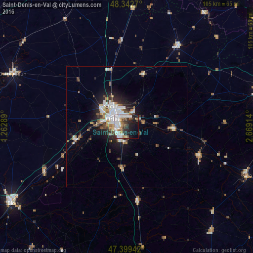
Analysis of Saint-Denis-en-Val night lights 2016
Square area 10x10 km:
 15.48%
90-99
14.35%80-89
2.41%70-79
1.7%60-69
5.11%50-59
6.11%40-49
5.11%30-39
5.97%20-29
12.36%10-19
17.9%0-9
13.49%Square area 50x50 km:
1.85%90-99
2.16%80-89
0.55%70-79
0.83%60-69
1.05%50-59
1.22%40-49
1.19%30-39
1.13%20-29
2.36%10-19
4.3%0-9
83.36%Clear (daylight) street map image can be seen on geolist.org.
Map coordinates:
48° 20' 33.7" North, 1° 15' 46.4" East
47° 52' 23.6" North, 1° 57' 57.6" East
47° 23' 57.9" North, 2° 40' 8.9" East
Some cities around Saint-Denis-en-Val sort by population:
• Orléans
5.7 km =3.5 mi,  305°
305°
• Olivet
5.1 km =3.2 mi,  256°
256°
• Fleury-les-Aubrais
7.6 km =4.7 mi,  331°
331°
• Saran
10.9 km =6.8 mi,  321°
321°
• La Chapelle-Saint-Mesmin
9.9 km =6.2 mi,  278°
278°
• Ingré
11.5 km =7.1 mi,  296°
296°
• Chécy
4.8 km =3 mi,  61°
61°
• La Ferté-Saint-Aubin
17.5 km =10.9 mi,  186°
186°
2980885 (p: 7,632)
Sources (retrieved 2019-11-25):
» Earth at Night: Flat Maps 2012, 2016