Séné night lights from space
Night Light of Séné (Brittany) from space (France) Src. Average luminocity for 10x10km area is 24.8869% and for 50x50km: 3.4185%.
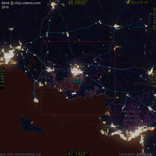
Analysis of Séné night lights 2016
Square area 10x10 km:
100  6.7%
6.7%
90-99 6.99%
80-89 1.19%
70-79 2.38%
60-69 1.49%
50-59 0.3%
40-49 1.79%
30-39 1.04%
20-29 5.06%
10-19 22.62%
0-9 50.45%
6.7%90-99
6.99%80-89
1.19%70-79
2.38%60-69
1.49%50-59
0.3%40-49
1.79%30-39
1.04%20-29
5.06%10-19
22.62%0-9
50.45%Square area 50x50 km:
100 0.5%
90-99 0.66%
80-89 0.22%
70-79 0.43%
60-69 0.25%
50-59 0.31%
40-49 0.58%
30-39 0.6%
20-29 0.72%
10-19 2.17%
0-9 93.57%
0.5%90-99
0.66%80-89
0.22%70-79
0.43%60-69
0.25%50-59
0.31%40-49
0.58%30-39
0.6%20-29
0.72%10-19
2.17%0-9
93.57%Clear (daylight) street map image can be seen on geolist.org.
Map coordinates:
48° 5' 26.9" North, 3° 26' 24.5" West
47° 37' 8.4" North, 2° 44' 13.2" West
47° 8' 34.4" North, 2° 2' 1.9" West
Some cities around Séné sort by population:
• Vannes
4.5 km =2.8 mi,  342°
342°
• Auray
19.9 km =12.4 mi,  286°
286°
• Saint-Avé
8 km =5 mi,  354°
354°
• Sarzeau
10.4 km =6.5 mi,  193°
193°
• Questembert
21.9 km =13.6 mi,  77°
77°
• Theix
6.5 km =4 mi, 79°
• Arradon
6.4 km =4 mi,  278°
278°
• Brech
22.7 km =14.1 mi,  300°
300°
2975113 (p: 8,465)
Sources (retrieved 2019-11-25):
» Earth at Night: Flat Maps 2012, 2016