Saint-Tropez night lights from space
Night Light of Saint-Tropez (Provence-Alpes-Côte d'Azur) from space (France) Src. Average luminocity for 10x10km area is 34.65% and for 50x50km: 11.5346%.
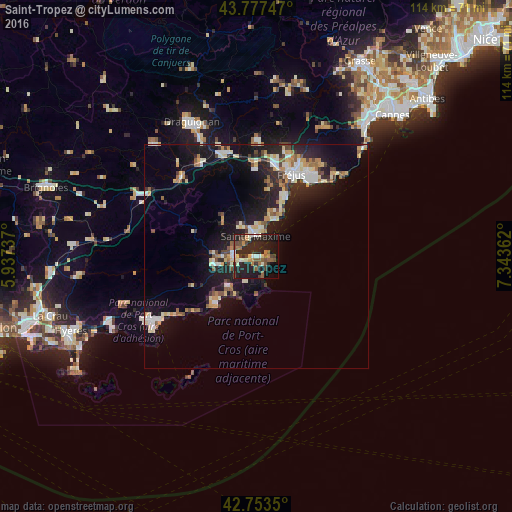
Analysis of Saint-Tropez night lights 2016
Square area 10x10 km:
 2.88%
2.88%90-99
5.76%80-89
2.58%70-79
3.94%60-69
3.79%50-59
7.12%40-49
6.52%30-39
4.55%20-29
25.3%10-19
25.45%0-9
12.12%Square area 50x50 km:
1.24%90-99
2.28%80-89
1.41%70-79
1.19%60-69
1.31%50-59
1.31%40-49
1.27%30-39
1.24%20-29
3.82%10-19
10.65%0-9
74.26%Clear (daylight) street map image can be seen on geolist.org.
Map coordinates:
43° 46' 38.9" North, 5° 56' 14.5" East
43° 16' 3.5" North, 6° 38' 25.8" East
42° 45' 12.6" North, 7° 20' 37" East
Some cities around Saint-Tropez sort by population:
• Fréjus
20 km =12.4 mi,  22°
22°
• Roquebrune-sur-Argens
19.5 km =12.1 mi,  359°
359°
• Cogolin
9.1 km =5.7 mi,  259°
259°
• Le Muy
23.6 km =14.7 mi,  345°
345°
• Vidauban
24.5 km =15.2 mi,  316°
316°
• Puget-sur-Argens
21.2 km =13.2 mi,  9°
9°
• Les Arcs
25.4 km =15.8 mi,  328°
328°
• Cavalaire-sur-Mer
13.9 km =8.6 mi,  220°
220°
2976742 (p: 5,939)
Sources (retrieved 2019-11-25):
» Earth at Night: Flat Maps 2012, 2016