Roquebrune-sur-Argens night lights from space
Night Light of Roquebrune-sur-Argens (Provence-Alpes-Côte d'Azur) from space (France) Src. Average luminocity for 10x10km area is 25.8524% and for 50x50km: 15.5361%.
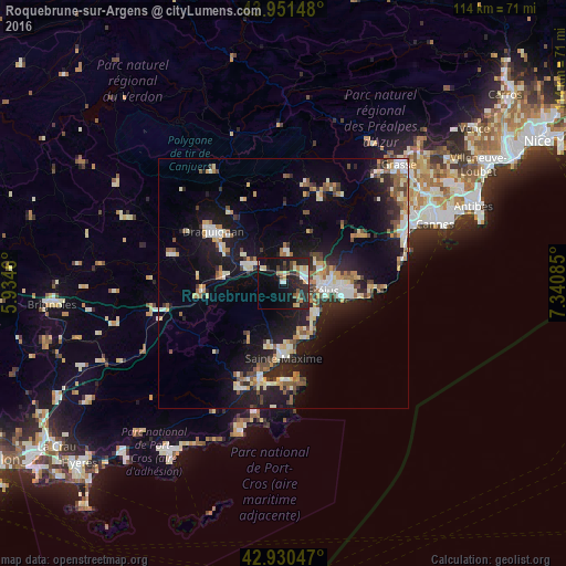
Analysis of Roquebrune-sur-Argens night lights 2016
Square area 10x10 km:
 1.9%
1.9%90-99
5.24%80-89
3.49%70-79
2.38%60-69
2.7%50-59
2.38%40-49
3.81%30-39
3.49%20-29
13.49%10-19
25.87%0-9
35.24%Square area 50x50 km:
1.7%90-99
3.07%80-89
1.7%70-79
1.5%60-69
1.91%50-59
1.89%40-49
1.92%30-39
1.76%20-29
4.79%10-19
13.81%0-9
65.94%Clear (daylight) street map image can be seen on geolist.org.
Map coordinates:
43° 57' 5.3" North, 5° 56' 4.6" East
43° 26' 35.3" North, 6° 38' 15.8" East
42° 55' 49.7" North, 7° 20' 27.1" East
Some cities around Roquebrune-sur-Argens sort by population:
• Fréjus
8 km =5 mi,  97°
97°
• Saint-Raphaël
11.2 km =7 mi, 101°
• Sainte-Maxime
14.9 km =9.3 mi,  179°
179°
• Le Muy
6.6 km =4.1 mi,  299°
299°
• Vidauban
16.7 km =10.4 mi,  263°
263°
• Puget-sur-Argens
4.1 km =2.5 mi,  69°
69°
• Les Arcs
13 km =8.1 mi,  279°
279°
• Trans-en-Provence
13.9 km =8.6 mi, 298°
2982875 (p: 12,485)
Sources (retrieved 2019-11-25):
» Earth at Night: Flat Maps 2012, 2016