Les Arcs night lights from space
Night Light of Les Arcs (Provence-Alpes-Côte d'Azur) from space (France) Src. Average luminocity for 10x10km area is 21.8857% and for 50x50km: 12.6212%.
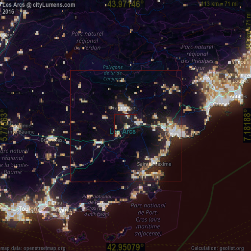
Analysis of Les Arcs night lights 2016
Square area 10x10 km:
 1.75%
1.75%90-99
4.29%80-89
2.38%70-79
2.38%60-69
3.49%50-59
0.79%40-49
1.59%30-39
1.9%20-29
1.59%10-19
39.52%0-9
40.32%Square area 50x50 km:
1.26%90-99
2.61%80-89
1.53%70-79
1.31%60-69
1.45%50-59
1.52%40-49
1.36%30-39
1.33%20-29
3.64%10-19
10%0-9
73.98%Clear (daylight) street map image can be seen on geolist.org.
Map coordinates:
43° 58' 17.3" North, 5° 46' 32.3" East
43° 27' 47.8" North, 6° 28' 43.5" East
42° 57' 2.8" North, 7° 10' 54.8" East
Some cities around Les Arcs sort by population:
• Draguignan
8.3 km =5.2 mi,  352°
352°
• Roquebrune-sur-Argens
13 km =8.1 mi,  99°
99°
• Le Muy
7.1 km =4.4 mi,  81°
81°
• Lorgues
10 km =6.2 mi,  289°
289°
• Le Luc
15.4 km =9.6 mi,  240°
240°
• Vidauban
5.5 km =3.4 mi,  223°
223°
• Puget-sur-Argens
16.7 km =10.4 mi,  92°
92°
• Trans-en-Provence
4.5 km =2.8 mi,  7°
7°
3002138 (p: 5,910)
Sources (retrieved 2019-11-25):
» Earth at Night: Flat Maps 2012, 2016