Cogolin night lights from space
Night Light of Cogolin (Provence-Alpes-Côte d'Azur) from space (France) Src. Average luminocity for 10x10km area is 27.7818% and for 50x50km: 11.5599%.
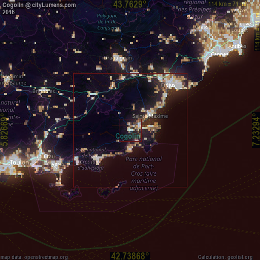
Analysis of Cogolin night lights 2016
Square area 10x10 km:
 2.42%
2.42%90-99
5.91%80-89
4.09%70-79
1.21%60-69
2.88%50-59
4.09%40-49
6.06%30-39
1.97%20-29
9.85%10-19
29.39%0-9
32.12%Square area 50x50 km:
1.33%90-99
2.35%80-89
1.45%70-79
1.19%60-69
1.27%50-59
1.38%40-49
1.18%30-39
1.19%20-29
3.56%10-19
9.08%0-9
76.01%Clear (daylight) street map image can be seen on geolist.org.
Map coordinates:
43° 45' 46.4" North, 5° 49' 36.1" East
43° 15' 10.6" North, 6° 31' 47.3" East
42° 44' 19.2" North, 7° 13' 58.6" East
Some cities around Cogolin sort by population:
• Sainte-Maxime
10.8 km =6.7 mi,  54°
54°
• Roquebrune-sur-Argens
22.9 km =14.2 mi,  22°
22°
• Le Luc
23.6 km =14.7 mi,  311°
311°
• Vidauban
20.9 km =13 mi,  337°
337°
• Bormes-les-Mimosas
18.9 km =11.7 mi,  233°
233°
• Saint-Tropez
9.1 km =5.7 mi,  79°
79°
• Le Lavandou
18.5 km =11.5 mi, 225°
• Cavalaire-sur-Mer
8.9 km =5.5 mi,  180°
180°
3024421 (p: 9,838)
Sources (retrieved 2019-11-25):
» Earth at Night: Flat Maps 2012, 2016