Beaucaire night lights from space
Night Light of Beaucaire (Occitanie) from space (France) Src. Average luminocity for 10x10km area is 31.9288% and for 50x50km: 20.7591%.
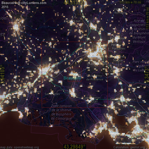
Analysis of Beaucaire night lights 2016
Square area 10x10 km:
 5.15%
5.15%90-99
7.27%80-89
1.82%70-79
4.09%60-69
5.61%50-59
1.82%40-49
1.52%30-39
1.06%20-29
4.7%10-19
53.48%0-9
13.48%Square area 50x50 km:
2.93%90-99
4.06%80-89
2.38%70-79
2.24%60-69
2.31%50-59
2.14%40-49
2.66%30-39
2.34%20-29
5.54%10-19
15.82%0-9
57.57%Clear (daylight) street map image can be seen on geolist.org.
Map coordinates:
44° 18' 48" North, 3° 56' 27.8" East
43° 48' 29" North, 4° 38' 39" East
43° 17' 54.6" North, 5° 20' 50.3" East
Some cities around Beaucaire sort by population:
• Arles
14.6 km =9.1 mi,  184°
184°
• Tarascon
1.3 km =0.8 mi,  100°
100°
• Châteaurenard
18.8 km =11.7 mi,  64°
64°
• Saint-Rémy-de-Provence
15.2 km =9.4 mi, 98°
• Marguerittes
17 km =10.6 mi,  289°
289°
• Manduel
13.8 km =8.6 mi,  274°
274°
• Bouillargues
17.3 km =10.7 mi, 266°
• Bellegarde
11.9 km =7.4 mi,  239°
239°
3034382 (p: 14,766)
Sources (retrieved 2019-11-25):
» Earth at Night: Flat Maps 2012, 2016