Saint-Raphaël night lights from space
Night Light of Saint-Raphaël (Provence-Alpes-Côte d'Azur) from space (France) Src. Average luminocity for 10x10km area is 56.7524% and for 50x50km: 18.7255%.

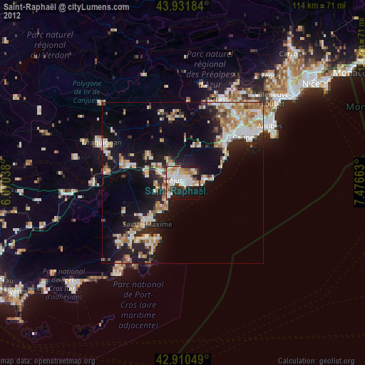
Analysis of Saint-Raphaël night lights 2016
Square area 10x10 km:
 14.29%
90-99
15.87%80-89
5.4%70-79
6.03%60-69
7.14%50-59
3.65%40-49
6.35%30-39
4.92%20-29
17.62%10-19
17.14%0-9
1.59%Square area 50x50 km:
2.58%90-99
4.29%80-89
2.01%70-79
1.86%60-69
2.64%50-59
2.09%40-49
2.01%30-39
2.13%20-29
5.41%10-19
13.77%0-9
61.2%Clear (daylight) street map image can be seen on geolist.org.
Map coordinates:
43° 55' 54.6" North, 6° 4' 13.4" East
43° 25' 24" North, 6° 46' 24.6" East
42° 54' 37.8" North, 7° 28' 35.9" East
Some cities around Saint-Raphaël sort by population:
• Cannes
24 km =14.9 mi,  53°
53°
• Fréjus
3.3 km =2.1 mi,  289°
289°
• Mandelieu-la-Napoule
19 km =11.8 mi,  44°
44°
• Roquebrune-sur-Argens
11.2 km =7 mi,  281°
281°
• Le Muy
17.6 km =10.9 mi, 288°
• Puget-sur-Argens
8 km =5 mi,  296°
296°
• Pégomas
23.1 km =14.4 mi,  33°
33°
• Les Arcs
24.2 km =15 mi, 280°
2977246 (p: 34,918)
Sources (retrieved 2019-11-25):
» Earth at Night: Flat Maps 2012, 2016