Saint-Mitre night lights from space
Night Light of Saint-Mitre (Provence-Alpes-Côte d'Azur) from space (France) Src. Average luminocity for 10x10km area is 78.8841% and for 50x50km: 31.5669%.
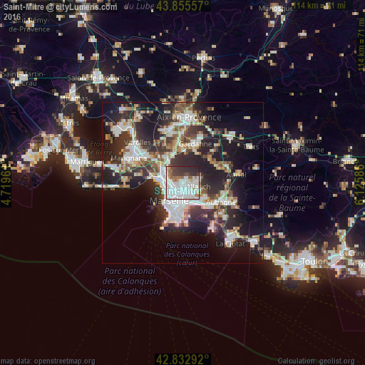
Analysis of Saint-Mitre night lights 2016
Square area 10x10 km:
 42.38%
90-99
19.68%80-89
1.27%70-79
2.22%60-69
7.3%50-59
3.97%40-49
5.4%30-39
9.05%20-29
8.57%10-19
0.16%0-9
0%Square area 50x50 km:
6.85%90-99
6.74%80-89
3.18%70-79
2.59%60-69
3.13%50-59
3.45%40-49
3.73%30-39
5.94%20-29
11.43%10-19
16.87%0-9
36.1%Clear (daylight) street map image can be seen on geolist.org.
Map coordinates:
43° 51' 20.1" North, 4° 43' 10.6" East
43° 20' 47" North, 5° 25' 21.9" East
42° 49' 58.5" North, 6° 7' 33.1" East
Some cities around Saint-Mitre sort by population:
• Marseille 13
3.3 km =2.1 mi,  200°
200°
• Marseille 14
3.5 km =2.2 mi,  266°
266°
• La Rose
2 km =1.2 mi,  166°
166°
• Montolivet
3.3 km =2.1 mi,  178°
178°
• Malpassé
2.8 km =1.7 mi,  192°
192°
• Plan-de-Cuques
3.3 km =2.1 mi,  87°
87°
• Le Merlan
1.5 km =0.9 mi,  234°
234°
• La Croix-Rouge
2.9 km =1.8 mi,  119°
119°
7646372 (p: 8,134)
Sources (retrieved 2019-11-25):
» Earth at Night: Flat Maps 2012, 2016