Malpassé night lights from space
Night Light of Malpassé (Provence-Alpes-Côte d'Azur) from space (France) Src. Average luminocity for 10x10km area is 94.7076% and for 50x50km: 30.1128%.
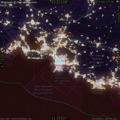
Analysis of Malpassé night lights 2016
Square area 10x10 km:
 59.39%
90-99
27.12%80-89
2.12%70-79
1.36%60-69
5.3%50-59
3.64%40-49
0.45%30-39
0.61%20-29
0%10-19
0%0-9
0%Square area 50x50 km:
6.75%90-99
6.64%80-89
3.05%70-79
2.38%60-69
2.9%50-59
3.09%40-49
3.37%30-39
5.66%20-29
10.79%10-19
15.53%0-9
39.84%Clear (daylight) street map image can be seen on geolist.org.
Map coordinates:
43° 49' 51.9" North, 4° 42' 44.6" East
43° 19' 18.1" North, 5° 24' 55.8" East
42° 48' 28.8" North, 6° 7' 7.1" East
Some cities around Malpassé sort by population:
• Marseille 13
0.7 km =0.4 mi,  238°
238°
• Saint-Barthélémy
1.5 km =0.9 mi,  314°
314°
• Saint-Just
0.9 km =0.6 mi, 236°
• La Rose
1.3 km =0.8 mi,  52°
52°
• Montolivet
0.8 km =0.5 mi,  128°
128°
• Saint-Jérôme
1.4 km =0.9 mi,  6°
6°
• Les Chartreux
1.5 km =0.9 mi,  216°
216°
• Le Merlan
2 km =1.2 mi,  341°
341°
11919777 (p: 11,148)
Sources (retrieved 2019-11-25):
» Earth at Night: Flat Maps 2012, 2016