La Rose night lights from space
Night Light of La Rose (Provence-Alpes-Côte d'Azur) from space (France) Src. Average luminocity for 10x10km area is 90.4045% and for 50x50km: 30.5723%.
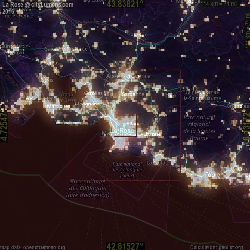
Analysis of La Rose night lights 2016
Square area 10x10 km:
 53.94%
90-99
24.85%80-89
1.97%70-79
1.97%60-69
6.52%50-59
3.79%40-49
3.48%30-39
2.88%20-29
0.61%10-19
0%0-9
0%Square area 50x50 km:
6.74%90-99
6.64%80-89
3.12%70-79
2.45%60-69
3.02%50-59
3.23%40-49
3.53%30-39
5.77%20-29
10.91%10-19
15.78%0-9
38.79%Clear (daylight) street map image can be seen on geolist.org.
Map coordinates:
43° 50' 17.6" North, 4° 43' 31.7" East
43° 19' 44" North, 5° 25' 42.9" East
42° 48' 55" North, 6° 7' 54.2" East
Some cities around La Rose sort by population:
• Marseille 13
2 km =1.2 mi,  234°
234°
• Saint-Barthélémy
2.1 km =1.3 mi,  276°
276°
• Montolivet
1.4 km =0.9 mi,  197°
197°
• Malpassé
1.3 km =0.8 mi, 232°
• Saint-Jérôme
1.1 km =0.7 mi,  302°
302°
• Le Merlan
2 km =1.2 mi, 303°
• Saint-Mitre
2 km =1.2 mi,  346°
346°
• La Croix-Rouge
2.1 km =1.3 mi,  76°
76°
11919776 (p: 13,835)
Sources (retrieved 2019-11-25):
» Earth at Night: Flat Maps 2012, 2016