Saint-Maximin-la-Sainte-Baume night lights from space
Night Light of Saint-Maximin-la-Sainte-Baume (Provence-Alpes-Côte d'Azur) from space (France) Src. Average luminocity for 10x10km area is 18.6603% and for 50x50km: 9.4523%.
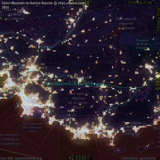
Analysis of Saint-Maximin-la-Sainte-Baume night lights 2016
Square area 10x10 km:
 0.79%
0.79%90-99
2.22%80-89
3.65%70-79
1.11%60-69
2.54%50-59
4.13%40-49
2.7%30-39
2.38%20-29
2.7%10-19
12.54%0-9
65.24%Square area 50x50 km:
0.64%90-99
1.42%80-89
1.58%70-79
0.99%60-69
1.23%50-59
1.12%40-49
1.21%30-39
1.11%20-29
2.29%10-19
6.76%0-9
81.66%Clear (daylight) street map image can be seen on geolist.org.
Map coordinates:
43° 57' 23.2" North, 5° 9' 27.6" East
43° 26' 53.3" North, 5° 51' 38.9" East
42° 56' 7.8" North, 6° 33' 50.1" East
Some cities around Saint-Maximin-la-Sainte-Baume sort by population:
• Brignoles
16.9 km =10.5 mi,  106°
106°
• Auriol
20.2 km =12.6 mi,  245°
245°
• Trets
14.3 km =8.9 mi,  270°
270°
• Roquevaire
23.4 km =14.5 mi,  242°
242°
• Fuveau
24.2 km =15 mi, 272°
• Garéoult
20 km =12.4 mi,  131°
131°
• Peypin
23.9 km =14.9 mi, 252°
• La Bouilladisse
22.4 km =13.9 mi,  255°
255°
2978100 (p: 15,225)
Sources (retrieved 2019-11-25):
» Earth at Night: Flat Maps 2012, 2016