Roquevaire night lights from space
Night Light of Roquevaire (Provence-Alpes-Côte d'Azur) from space (France) Src. Average luminocity for 10x10km area is 32.2921% and for 50x50km: 28.1029%.
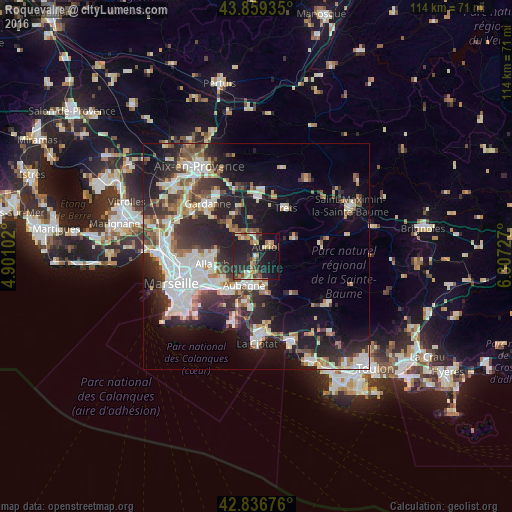
Analysis of Roquevaire night lights 2016
Square area 10x10 km:
 0.63%
0.63%90-99
3.81%80-89
5.24%70-79
5.71%60-69
4.29%50-59
2.86%40-49
6.35%30-39
3.97%20-29
20.79%10-19
34.13%0-9
12.22%Square area 50x50 km:
5.93%90-99
5.78%80-89
2.94%70-79
2.14%60-69
3.14%50-59
3.29%40-49
3.36%30-39
4.68%20-29
9.68%10-19
14.96%0-9
44.1%Clear (daylight) street map image can be seen on geolist.org.
Map coordinates:
43° 51' 33.7" North, 4° 54' 3.7" East
43° 21' 0.8" North, 5° 36' 14.9" East
42° 50' 12.3" North, 6° 18' 26.2" East
Some cities around Roquevaire sort by population:
• Aubagne
6.9 km =4.3 mi,  202°
202°
• Allauch
10 km =6.2 mi,  260°
260°
• Auriol
3.4 km =2.1 mi,  45°
45°
• Carnoux-en-Provence
10.9 km =6.8 mi, 197°
• La Penne-sur-Huveaune
10.4 km =6.5 mi,  223°
223°
• Gémenos
6.2 km =3.9 mi,  161°
161°
• Peypin
4.4 km =2.7 mi,  331°
331°
• La Bouilladisse
5.2 km =3.2 mi,  350°
350°
2982835 (p: 8,210)
Sources (retrieved 2019-11-25):
» Earth at Night: Flat Maps 2012, 2016