Auriol night lights from space
Night Light of Auriol (Provence-Alpes-Côte d'Azur) from space (France) Src. Average luminocity for 10x10km area is 23.6873% and for 50x50km: 26.7823%.
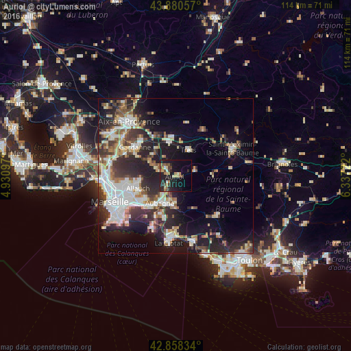
Analysis of Auriol night lights 2016
Square area 10x10 km:
 0.63%
0.63%90-99
1.43%80-89
4.13%70-79
3.49%60-69
3.97%50-59
2.7%40-49
5.4%30-39
2.22%20-29
10.63%10-19
28.57%0-9
36.83%Square area 50x50 km:
5.63%90-99
5.39%80-89
2.85%70-79
2.11%60-69
2.88%50-59
3.11%40-49
3.36%30-39
4.53%20-29
9.33%10-19
14.16%0-9
46.65%Clear (daylight) street map image can be seen on geolist.org.
Map coordinates:
43° 52' 50.1" North, 4° 55' 51.5" East
43° 22' 17.8" North, 5° 38' 2.8" East
42° 51' 30" North, 6° 20' 14" East
Some cities around Auriol sort by population:
• Aubagne
10.2 km =6.3 mi,  210°
210°
• Allauch
12.9 km =8 mi,  252°
252°
• Trets
9.4 km =5.8 mi,  25°
25°
• Roquevaire
3.4 km =2.1 mi,  225°
225°
• Fuveau
11 km =6.8 mi,  327°
327°
• Gémenos
8.3 km =5.2 mi,  183°
183°
• Peypin
4.8 km =3 mi,  288°
288°
• La Bouilladisse
4.3 km =2.7 mi,  309°
309°
3036012 (p: 9,872)
Sources (retrieved 2019-11-25):
» Earth at Night: Flat Maps 2012, 2016