Fuveau night lights from space
Night Light of Fuveau (Provence-Alpes-Côte d'Azur) from space (France) Src. Average luminocity for 10x10km area is 34.2508% and for 50x50km: 26.5131%.
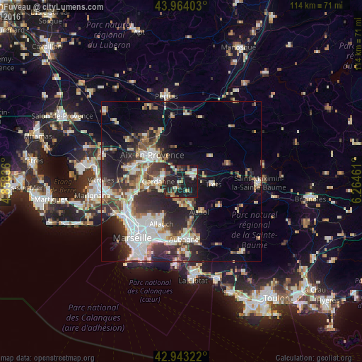
Analysis of Fuveau night lights 2016
Square area 10x10 km:
 3.49%
3.49%90-99
5.56%80-89
4.6%70-79
1.11%60-69
4.76%50-59
2.06%40-49
7.46%30-39
3.17%20-29
21.11%10-19
46.51%0-9
0.16%Square area 50x50 km:
5.53%90-99
5.44%80-89
2.85%70-79
2.22%60-69
2.65%50-59
3.27%40-49
3.4%30-39
4.8%20-29
8.62%10-19
12.09%0-9
49.13%Clear (daylight) street map image can be seen on geolist.org.
Map coordinates:
43° 57' 50.5" North, 4° 51' 30.1" East
43° 27' 20.8" North, 5° 33' 41.4" East
42° 56' 35.6" North, 6° 15' 52.6" East
Some cities around Fuveau sort by population:
• Aix-en-Provence
12.1 km =7.5 mi,  311°
311°
• Gardanne
7.5 km =4.7 mi,  269°
269°
• Bouc-Bel-Air
12 km =7.5 mi, 268°
• Auriol
11 km =6.8 mi,  147°
147°
• Trets
9.9 km =6.2 mi,  94°
94°
• Simiane-Collongue
10.6 km =6.6 mi,  254°
254°
• Peypin
8 km =5 mi,  170°
170°
• La Bouilladisse
7.1 km =4.4 mi,  158°
158°
3016878 (p: 7,845)
Sources (retrieved 2019-11-25):
» Earth at Night: Flat Maps 2012, 2016