Saint-Martin-des-Champs night lights from space
Night Light of Saint-Martin-des-Champs (Brittany) from space (France) Src. Average luminocity for 10x10km area is 12.4821% and for 50x50km: 1.1505%.
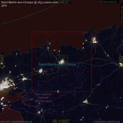
Analysis of Saint-Martin-des-Champs night lights 2016
Square area 10x10 km:
 1.19%
1.19%90-99
1.19%80-89
1.93%70-79
2.23%60-69
2.38%50-59
2.68%40-49
1.49%30-39
0%20-29
0.6%10-19
1.34%0-9
84.97%Square area 50x50 km:
0.09%90-99
0.22%80-89
0.18%70-79
0.19%60-69
0.11%50-59
0.11%40-49
0.14%30-39
0.1%20-29
0.09%10-19
0.13%0-9
98.64%Clear (daylight) street map image can be seen on geolist.org.
Map coordinates:
49° 2' 46.8" North, 4° 32' 11.2" West
48° 34' 60" North, 3° 49' 60" West
48° 6' 57.8" North, 3° 7' 48.7" West
Some cities around Saint-Martin-des-Champs sort by population:
• Lannion
32.3 km =20.1 mi,  59°
59°
• Morlaix
0.8 km =0.5 mi,  148°
148°
• Landerneau
34.1 km =21.2 mi,  244°
244°
• Landivisiau
19.2 km =11.9 mi, 244°
• Carhaix-Plouguer
39.2 km =24.4 mi, 150°
• Perros-Guirec
38.7 km =24 mi,  48°
48°
• Plabennec
44.6 km =27.7 mi,  258°
258°
• Lesneven
35.9 km =22.3 mi,  268°
268°
2978351 (p: 5,033)
Sources (retrieved 2019-11-25):
» Earth at Night: Flat Maps 2012, 2016