Saint-Hilaire-de-Talmont night lights from space
Night Light of Saint-Hilaire-de-Talmont (Pays de la Loire) from space (France) Src. Average luminocity for 10x10km area is 2.0966% and for 50x50km: 3.1169%.
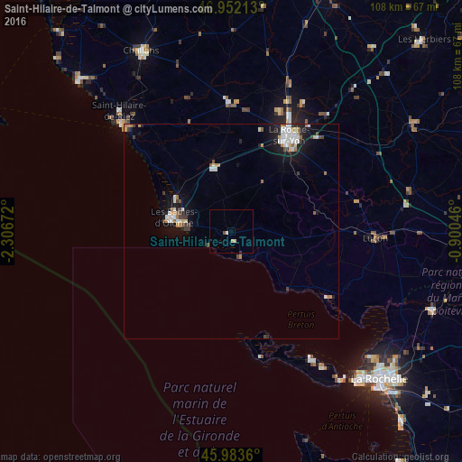
Analysis of Saint-Hilaire-de-Talmont night lights 2016
Square area 10x10 km:
 0.28%
0.28%90-99
0.28%80-89
0.57%70-79
0.57%60-69
0%50-59
0%40-49
0.57%30-39
0.28%20-29
0%10-19
0%0-9
97.44%Square area 50x50 km:
0.58%90-99
0.65%80-89
0.2%70-79
0.43%60-69
0.28%50-59
0.21%40-49
0.3%30-39
0.43%20-29
0.51%10-19
2.35%0-9
94.07%Clear (daylight) street map image can be seen on geolist.org.
Map coordinates:
46° 57' 7.7" North, 2° 18' 24.2" West
46° 28' 12.1" North, 1° 36' 12.9" West
45° 59' 1" North, 0° 54' 1.7" West
Some cities around Saint-Hilaire-de-Talmont sort by population:
• La Roche-sur-Yon
25.4 km =15.8 mi,  30°
30°
• Les Sables-d’Olonne
14.2 km =8.8 mi,  281°
281°
• Château-d’Olonne
11.2 km =7 mi,  289°
289°
• Olonne-sur-Mer
14.9 km =9.3 mi,  299°
299°
• Luçon
33.6 km =20.9 mi,  92°
92°
• Aizenay
30 km =18.6 mi,  359°
359°
• Le Poiré-sur-Vie
34 km =21.1 mi,  12°
12°
• Nieul-sur-Mer
44.7 km =27.8 mi,  131°
131°
2979539 (p: 5,737)
Sources (retrieved 2019-11-25):
» Earth at Night: Flat Maps 2012, 2016