Saint-Gilles-Croix-de-Vie night lights from space
Night Light of Saint-Gilles-Croix-de-Vie (Pays de la Loire) from space (France) Src. Average luminocity for 10x10km area is 13.0268% and for 50x50km: 2.9523%.
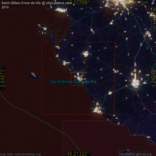
Analysis of Saint-Gilles-Croix-de-Vie night lights 2016
Square area 10x10 km:
 0.74%
0.74%90-99
1.04%80-89
1.34%70-79
3.13%60-69
2.23%50-59
2.23%40-49
1.79%30-39
3.13%20-29
1.49%10-19
1.93%0-9
80.95%Square area 50x50 km:
0.28%90-99
0.53%80-89
0.23%70-79
0.37%60-69
0.41%50-59
0.41%40-49
0.33%30-39
0.57%20-29
0.55%10-19
0.84%0-9
95.47%Clear (daylight) street map image can be seen on geolist.org.
Map coordinates:
47° 10' 39.7" North, 2° 38' 55.4" West
46° 41' 51.4" North, 1° 56' 44.2" West
46° 12' 47.6" North, 1° 14' 32.9" West
Some cities around Saint-Gilles-Croix-de-Vie sort by population:
• La Roche-sur-Yon
39.2 km =24.4 mi,  95°
95°
• Challans
17.1 km =10.6 mi,  18°
18°
• Les Sables-d’Olonne
25.5 km =15.8 mi,  151°
151°
• Château-d’Olonne
26.6 km =16.5 mi,  144°
144°
• Olonne-sur-Mer
22.4 km =13.9 mi, 143°
• Aizenay
26.1 km =16.2 mi,  79°
79°
• Le Poiré-sur-Vie
34.2 km =21.3 mi, 76°
• Machecoul
34.2 km =21.3 mi, 15°
2979662 (p: 7,280)
Sources (retrieved 2019-11-25):
» Earth at Night: Flat Maps 2012, 2016