Challans night lights from space
Night Light of Challans (Pays de la Loire) from space (France) Src. Average luminocity for 10x10km area is 12.4494% and for 50x50km: 2.4991%.
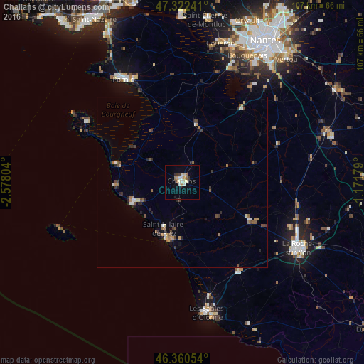
Analysis of Challans night lights 2016
Square area 10x10 km:
 1.34%
1.34%90-99
3.42%80-89
1.19%70-79
1.19%60-69
1.79%50-59
1.19%40-49
0.15%30-39
1.79%20-29
1.04%10-19
1.93%0-9
84.97%Square area 50x50 km:
0.18%90-99
0.36%80-89
0.21%70-79
0.28%60-69
0.37%50-59
0.46%40-49
0.4%30-39
0.46%20-29
0.66%10-19
0.28%0-9
96.34%Clear (daylight) street map image can be seen on geolist.org.
Map coordinates:
47° 19' 20.7" North, 2° 34' 40.9" West
46° 50' 37.1" North, 1° 52' 29.7" West
46° 21' 37.9" North, 1° 10' 18.4" West
Some cities around Challans sort by population:
• Pornic
34 km =21.1 mi,  331°
331°
• Saint-Hilaire-de-Riez
15 km =9.3 mi,  194°
194°
• Saint-Jean-de-Monts
16.8 km =10.4 mi,  249°
249°
• Saint-Gilles-Croix-de-Vie
17.1 km =10.6 mi,  198°
198°
• Saint-Philbert-de-Grand-Lieu
27.8 km =17.3 mi,  39°
39°
• Aizenay
23.3 km =14.5 mi,  119°
119°
• Le Poiré-sur-Vie
29 km =18 mi,  106°
106°
• Machecoul
17.1 km =10.6 mi,  13°
13°
3027513 (p: 18,947)
Sources (retrieved 2019-11-25):
» Earth at Night: Flat Maps 2012, 2016