Saint-Gély-du-Fesc night lights from space
Night Light of Saint-Gély-du-Fesc (Occitanie) from space (France) Src. Average luminocity for 10x10km area is 35.3242% and for 50x50km: 18.4528%.
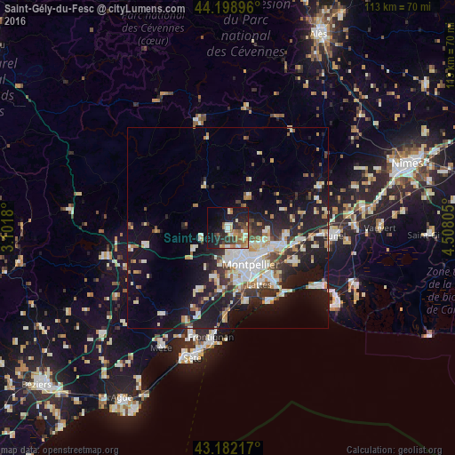
Analysis of Saint-Gély-du-Fesc night lights 2016
Square area 10x10 km:
 3.79%
3.79%90-99
5.91%80-89
3.94%70-79
5%60-69
6.97%50-59
4.7%40-49
3.48%30-39
7.58%20-29
10.3%10-19
30%0-9
18.33%Square area 50x50 km:
3.44%90-99
3.86%80-89
1.94%70-79
1.83%60-69
2.25%50-59
1.46%40-49
1.59%30-39
2.52%20-29
5.81%10-19
13.99%0-9
61.31%Clear (daylight) street map image can be seen on geolist.org.
Map coordinates:
44° 11' 56.3" North, 3° 6' 6.5" East
43° 41' 33.8" North, 3° 48' 17.7" East
43° 10' 55.8" North, 4° 30' 29" East
Some cities around Saint-Gély-du-Fesc sort by population:
• Montpellier
10.8 km =6.7 mi,  147°
147°
• Castelnau-le-Lez
10.1 km =6.3 mi,  130°
130°
• Le Crès
11.9 km =7.4 mi,  114°
114°
• Pignan
12.7 km =7.9 mi,  196°
196°
• Juvignac
8.8 km =5.5 mi,  177°
177°
• Grabels
5 km =3.1 mi,  185°
185°
• Clapiers
7.8 km =4.8 mi,  119°
119°
• Jacou
9.3 km =5.8 mi, 111°
2980033 (p: 8,605)
Sources (retrieved 2019-11-25):
» Earth at Night: Flat Maps 2012, 2016