Jacou night lights from space
Night Light of Jacou (Occitanie) from space (France) Src. Average luminocity for 10x10km area is 68.3515% and for 50x50km: 22.1803%.
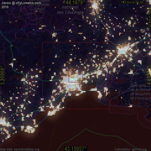
Analysis of Jacou night lights 2016
Square area 10x10 km:
 21.82%
90-99
14.7%80-89
9.24%70-79
8.94%60-69
5.15%50-59
7.58%40-49
8.48%30-39
10.45%20-29
13.33%10-19
0.3%0-9
0%Square area 50x50 km:
4.14%90-99
4.65%80-89
2.56%70-79
2.17%60-69
2.35%50-59
1.68%40-49
1.81%30-39
2.83%20-29
8.03%10-19
18.23%0-9
51.56%Clear (daylight) street map image can be seen on geolist.org.
Map coordinates:
44° 10' 4.4" North, 3° 12' 32.7" East
43° 39' 41" North, 3° 54' 44" East
43° 9' 2.1" North, 4° 36' 55.2" East
Some cities around Jacou sort by population:
• Montpellier
6.3 km =3.9 mi,  206°
206°
• Castelnau-le-Lez
3.3 km =2.1 mi,  197°
197°
• Le Crès
2.7 km =1.7 mi,  123°
123°
• Baillargues
8.4 km =5.2 mi,  89°
89°
• Vendargues
4.7 km =2.9 mi, 94°
• Castries
6 km =3.7 mi,  70°
70°
• Clapiers
1.9 km =1.2 mi,  259°
259°
• Saint-Clément-de-Rivière
6.8 km =4.2 mi,  291°
291°
3012576 (p: 5,111)
Sources (retrieved 2019-11-25):
» Earth at Night: Flat Maps 2012, 2016