Saint-Antoine night lights from space
Night Light of Saint-Antoine (Provence-Alpes-Côte d'Azur) from space (France) Src. Average luminocity for 10x10km area is 69.5571% and for 50x50km: 32.6297%.
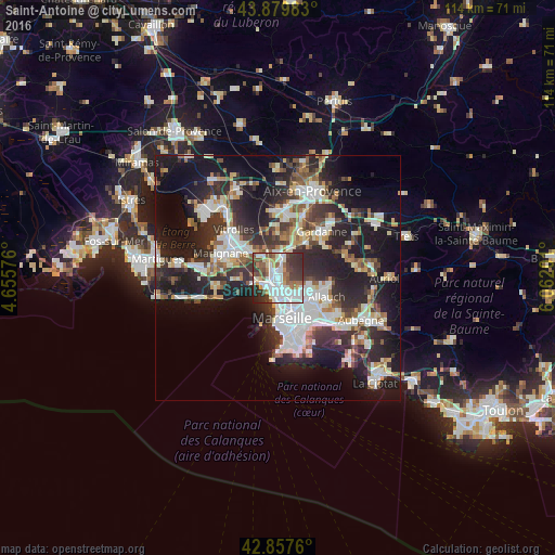
Analysis of Saint-Antoine night lights 2016
Square area 10x10 km:
 20.48%
90-99
20.79%80-89
4.44%70-79
5.24%60-69
7.46%50-59
10%40-49
8.89%30-39
14.76%20-29
7.46%10-19
0.48%0-9
0%Square area 50x50 km:
6.93%90-99
6.77%80-89
3.24%70-79
2.7%60-69
3.17%50-59
3.74%40-49
3.85%30-39
6.23%20-29
12.32%10-19
19.06%0-9
32%Clear (daylight) street map image can be seen on geolist.org.
Map coordinates:
43° 52' 47.4" North, 4° 39' 20.7" East
43° 22' 15.1" North, 5° 21' 32" East
42° 51' 27.4" North, 6° 3' 43.2" East
Some cities around Saint-Antoine sort by population:
• Marseille 15
0.4 km =0.2 mi,  290°
290°
• Marseille 16
2.3 km =1.4 mi,  238°
238°
• Notre-Dame Limite
1.2 km =0.7 mi,  14°
14°
• Septèmes-les-Vallons
3.1 km =1.9 mi, 10°
• Verduron
1.1 km =0.7 mi,  268°
268°
• La Viste
1.3 km =0.8 mi,  188°
188°
• Les Aygalades
1.8 km =1.1 mi,  147°
147°
• La Delorme
3.2 km =2 mi,  159°
159°
2981690 (p: 6,436)
Sources (retrieved 2019-11-25):
» Earth at Night: Flat Maps 2012, 2016