La Delorme night lights from space
Night Light of La Delorme (Provence-Alpes-Côte d'Azur) from space (France) Src. Average luminocity for 10x10km area is 77.1095% and for 50x50km: 31.5032%.
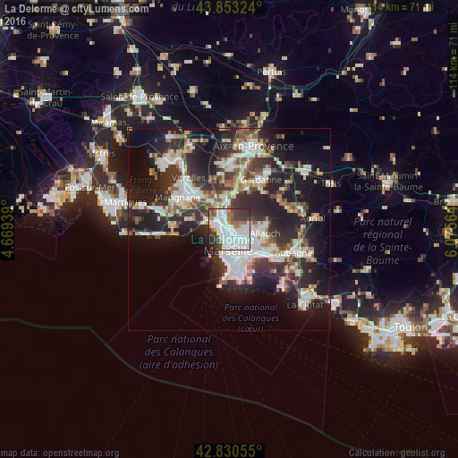
Analysis of La Delorme night lights 2016
Square area 10x10 km:
 39.37%
90-99
18.73%80-89
0.79%70-79
3.97%60-69
6.03%50-59
5.4%40-49
7.3%30-39
11.75%20-29
6.19%10-19
0.48%0-9
0%Square area 50x50 km:
6.84%90-99
6.65%80-89
3.13%70-79
2.58%60-69
3.08%50-59
3.49%40-49
3.62%30-39
5.99%20-29
11.78%10-19
17.19%0-9
35.65%Clear (daylight) street map image can be seen on geolist.org.
Map coordinates:
43° 51' 11.7" North, 4° 40' 9.8" East
43° 20' 38.6" North, 5° 22' 21" East
42° 49' 50" North, 6° 4' 32.3" East
Some cities around La Delorme sort by population:
• Marseille 14
0.6 km =0.4 mi,  85°
85°
• La Cabucelle
1.6 km =1 mi,  214°
214°
• Saint-Louis
1.5 km =0.9 mi,  287°
287°
• Le Canet
2 km =1.2 mi,  180°
180°
• Les Aygalades
1.5 km =0.9 mi,  355°
355°
• La Calade
1.8 km =1.1 mi,  251°
251°
• Les Arnavaux
1.2 km =0.7 mi,  149°
149°
• Saint-Joseph
0.6 km =0.4 mi,  68°
68°
11919785 (p: 6,066)
Sources (retrieved 2019-11-25):
» Earth at Night: Flat Maps 2012, 2016