Marseille 16 night lights from space
Night Light of Marseille 16 (Provence-Alpes-Côte d'Azur) from space (France) Src. Average luminocity for 10x10km area is 63.681% and for 50x50km: 32.759%.
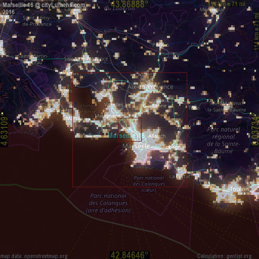
Analysis of Marseille 16 night lights 2016
Square area 10x10 km:
 20%
20%90-99
16.35%80-89
4.13%70-79
5.08%60-69
5.71%50-59
9.68%40-49
8.1%30-39
12.7%20-29
9.68%10-19
7.46%0-9
1.11%Square area 50x50 km:
7.13%90-99
6.98%80-89
3.2%70-79
2.61%60-69
3.13%50-59
3.86%40-49
3.88%30-39
6.28%20-29
12.35%10-19
18.1%0-9
32.48%Clear (daylight) street map image can be seen on geolist.org.
Map coordinates:
43° 52' 8" North, 4° 37' 51.9" East
43° 21' 35.4" North, 5° 20' 3.2" East
42° 50' 47.3" North, 6° 2' 14.4" East
Some cities around Marseille 16 sort by population:
• Saint-Louis
2.1 km =1.3 mi,  128°
128°
• Verduron
1.5 km =0.9 mi,  36°
36°
• La Viste
1.8 km =1.1 mi,  91°
91°
• Les Aygalades
3 km =1.9 mi,  95°
95°
• Saint-Antoine
2.3 km =1.4 mi,  58°
58°
• L'Estaque
2.1 km =1.3 mi,  282°
282°
• La Calade
2.7 km =1.7 mi,  149°
149°
• Saint-Henri
0.3 km =0.2 mi,  303°
303°
7284897 (p: 17,630)
Sources (retrieved 2019-11-25):
» Earth at Night: Flat Maps 2012, 2016