Verduron night lights from space
Night Light of Verduron (Provence-Alpes-Côte d'Azur) from space (France) Src. Average luminocity for 10x10km area is 67.7429% and for 50x50km: 32.9504%.
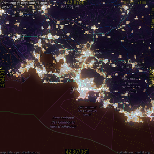
Analysis of Verduron night lights 2016
Square area 10x10 km:
 18.89%
90-99
20%80-89
4.76%70-79
4.92%60-69
6.83%50-59
11.27%40-49
9.37%30-39
14.6%20-29
6.67%10-19
2.7%0-9
0%Square area 50x50 km:
7.06%90-99
6.89%80-89
3.31%70-79
2.7%60-69
3.2%50-59
3.79%40-49
3.83%30-39
6.27%20-29
12.44%10-19
19.02%0-9
31.49%Clear (daylight) street map image can be seen on geolist.org.
Map coordinates:
43° 52' 46.6" North, 4° 38' 31.2" East
43° 22' 14.3" North, 5° 20' 42.5" East
42° 51' 26.5" North, 6° 2' 53.7" East
Some cities around Verduron sort by population:
• Marseille 15
0.7 km =0.4 mi,  75°
75°
• Marseille 16
1.5 km =0.9 mi,  216°
216°
• Notre-Dame Limite
1.9 km =1.2 mi,  49°
49°
• Saint-Louis
2.6 km =1.6 mi,  162°
162°
• La Viste
1.6 km =1 mi,  143°
143°
• Les Aygalades
2.6 km =1.6 mi,  125°
125°
• Saint-Antoine
1.1 km =0.7 mi,  88°
88°
• Saint-Henri
1.5 km =0.9 mi,  229°
229°
11919788 (p: 8,846)
Sources (retrieved 2019-11-25):
» Earth at Night: Flat Maps 2012, 2016