Septèmes-les-Vallons night lights from space
Night Light of Septèmes-les-Vallons (Provence-Alpes-Côte d'Azur) from space (France) Src. Average luminocity for 10x10km area is 62.1508% and for 50x50km: 33.1679%.
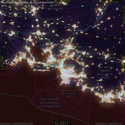
Analysis of Septèmes-les-Vallons night lights 2016
Square area 10x10 km:
 9.84%
9.84%90-99
15.08%80-89
6.98%70-79
6.19%60-69
10.48%50-59
10.63%40-49
12.38%30-39
21.43%20-29
6.98%10-19
0%0-9
0%Square area 50x50 km:
6.87%90-99
6.82%80-89
3.35%70-79
2.8%60-69
3.23%50-59
3.78%40-49
3.92%30-39
6.25%20-29
12.6%10-19
19.51%0-9
30.87%Clear (daylight) street map image can be seen on geolist.org.
Map coordinates:
43° 54' 25.5" North, 4° 39' 46.2" East
43° 23' 54" North, 5° 21' 57.5" East
42° 53' 7.1" North, 6° 4' 8.7" East
Some cities around Septèmes-les-Vallons sort by population:
• Marseille 15
3.1 km =1.9 mi,  198°
198°
• Les Pennes-Mirabeau
4.8 km =3 mi,  285°
285°
• Notre-Dame Limite
1.9 km =1.2 mi,  188°
188°
• Verduron
3.5 km =2.2 mi,  208°
208°
• Cabriès
4.9 km =3 mi,  12°
12°
• La Viste
4.4 km =2.7 mi, 190°
• Les Aygalades
4.6 km =2.9 mi,  174°
174°
• Saint-Antoine
3.1 km =1.9 mi, 190°
2975020 (p: 10,220)
Sources (retrieved 2019-11-25):
» Earth at Night: Flat Maps 2012, 2016