Publier night lights from space
Night Light of Publier (Auvergne-Rhône-Alpes) from space (France) Src. Average luminocity for 10x10km area is 32.4702% and for 50x50km: 13.7823%.
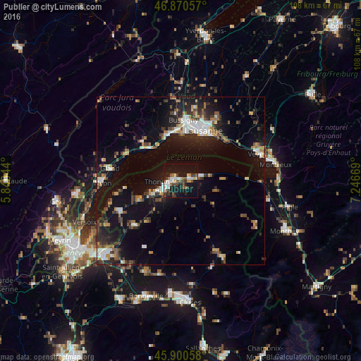
Analysis of Publier night lights 2016
Square area 10x10 km:
 5.65%
5.65%90-99
6.85%80-89
1.49%70-79
2.38%60-69
3.27%50-59
4.17%40-49
5.51%30-39
6.25%20-29
6.25%10-19
41.22%0-9
16.96%Square area 50x50 km:
1.69%90-99
2.26%80-89
1.01%70-79
1.38%60-69
1.55%50-59
1.68%40-49
2.19%30-39
2.4%20-29
3.92%10-19
12.53%0-9
69.4%Clear (daylight) street map image can be seen on geolist.org.
Map coordinates:
46° 52' 14.1" North, 5° 50' 25.6" East
46° 23' 15.8" North, 6° 32' 36.8" East
45° 54' 2.1" North, 7° 14' 48.1" East
Some cities around Publier sort by population:
• Lausanne, CH
15.8 km =9.8 mi,  25°
25°
• Thonon-les-Bains
5.2 km =3.2 mi,  248°
248°
• Pully, CH
16.4 km =10.2 mi, 33°
• Morges, CH
14.2 km =8.8 mi,  345°
345°
• Ecublens, CH
15.8 km =9.8 mi,  5°
5°
• Lutry, CH
16.8 km =10.4 mi,  40°
40°
• Évian-les-Bains
3.7 km =2.3 mi,  66°
66°
• Chavannes, CH
16 km =9.9 mi, 7°
2985163 (p: 5,525)
Sources (retrieved 2019-11-25):
» Earth at Night: Flat Maps 2012, 2016