Privas night lights from space
Night Light of Privas (Auvergne-Rhône-Alpes) from space (France) Src. Average luminocity for 10x10km area is 11.6924% and for 50x50km: 8.9931%.
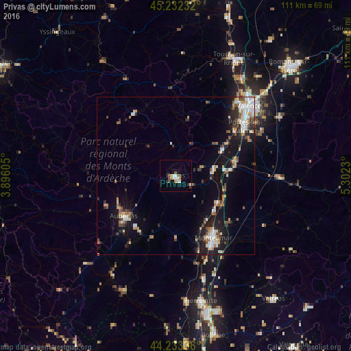
Analysis of Privas night lights 2016
Square area 10x10 km:
 0.91%
0.91%90-99
3.64%80-89
0.3%70-79
1.21%60-69
1.21%50-59
1.82%40-49
1.82%30-39
1.21%20-29
0.61%10-19
0.3%0-9
86.97%Square area 50x50 km:
1.16%90-99
1.86%80-89
0.71%70-79
0.97%60-69
1.09%50-59
0.94%40-49
1.33%30-39
1.1%20-29
2.14%10-19
6.94%0-9
81.74%Clear (daylight) street map image can be seen on geolist.org.
Map coordinates:
45° 13' 56.4" North, 3° 53' 45.8" East
44° 44' 6" North, 4° 35' 57" East
44° 14' 0.1" North, 5° 18' 8.3" East
Some cities around Privas sort by population:
• Montélimar
23.5 km =14.6 mi,  148°
148°
• Aubenas
20.9 km =13 mi,  232°
232°
• Portes-lès-Valence
26.8 km =16.7 mi,  54°
54°
• Le Teil
22.1 km =13.7 mi,  162°
162°
• Livron-sur-Drôme
19.7 km =12.2 mi,  76°
76°
• Saint-Péray
30.7 km =19.1 mi,  39°
39°
• Loriol-sur-Drôme
17.3 km =10.7 mi,  85°
85°
• La Voulte-sur-Rhône
15.9 km =9.9 mi,  63°
63°
2985290 (p: 9,545)
Sources (retrieved 2019-11-25):
» Earth at Night: Flat Maps 2012, 2016